
Gracias por apoyar a este sitio ❤️
Haz una donación
Haz una donación
Mapa topográfico Gandhinagar
Haga clic en el mapa para ver la altitud.
Gracias por apoyar a este sitio ❤️
Haz una donación
Haz una donación
Gandhinagar
Gandhinagar tiene una elevación promedio de 81 metros. La ciudad se encuentra en las orillas del río Sabarmati. Los 20 543 km² alrededor de Gandhinagar se define por tramos en el territorio guyaratí. Tiene un área de 205 km² (79.15 millas cuadradas). El río se seca con frecuencia en el verano, dejando solo un pequeño charco de agua.
Gracias por apoyar a este sitio ❤️
Haz una donación
Haz una donación
Acerca de este mapa
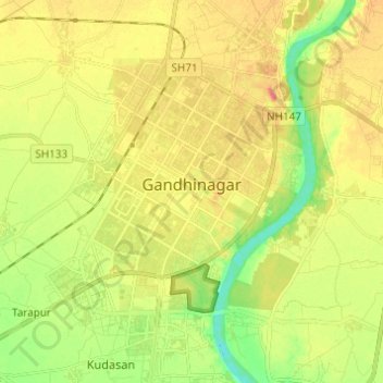
Nombre: Mapa topográfico Gandhinagar, altitud, relieve.
Lugar: Gandhinagar, Gandhinagar Taluka, Gandhinagar, Guyarat, India (23.16497 72.60257 23.27701 72.68906)
Altitud media: 75 m
Altitud mínima: 45 m
Altitud máxima: 104 m
Gracias por apoyar a este sitio ❤️
Haz una donación
Haz una donación