
Gracias por apoyar a este sitio ❤️
Haz una donación
Haz una donación
Mapa topográfico Vinhais
Haga clic en el mapa para ver la altitud.
Gracias por apoyar a este sitio ❤️
Haz una donación
Haz una donación
Acerca de este mapa
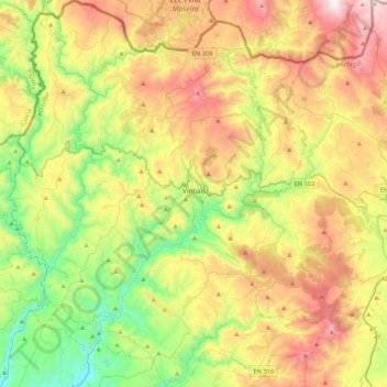
Nombre: Mapa topográfico Vinhais, altitud, relieve.
Lugar: Vinhais, Bragança, Portugal (41.67113 -7.21360 41.99076 -6.86096)
Altitud media: 779 m
Altitud mínima: 258 m
Altitud máxima: 1.527 m
Gracias por apoyar a este sitio ❤️
Haz una donación
Haz una donación
Otros mapas topográficos
Haga clic en un mapa para ver su topografía, su altitud y su relieve.
Gracias por apoyar a este sitio ❤️
Haz una donación
Haz una donación
Gracias por apoyar a este sitio ❤️
Haz una donación
Haz una donación