Geolocalizar

Mapa topográfico Bulawayo

Mapa interactivo

Haga clic en el mapa para ver la altitud.

Acerca de este mapa

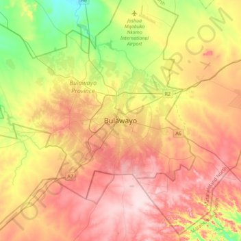
Nombre: Mapa topográfico Bulawayo, altitud, relieve.

Lugar: Bulawayo, Bulawayo Province, 00000, Zimbabwe (-20.31606 28.42871 -19.99606 28.74871)

Altitud media: 1.348 m

Altitud mínima: 1.210 m

Altitud máxima: 1.479 m

Bulawayo experiences water shortages in drought seasons due to the overwhelming increase in population versus the static and sometimes decreasing capacity of the reserve dams. The geographical factors causing water scarcity are rising temperatures, the area's high elevation and the arid environment of Matabeleland. Bulawayo provides residents with water by using a system of dams, treatment plants, and reservoirs.