
Haz una donación
Mapa topográfico Panyab
Haga clic en el mapa para ver la altitud.
Haz una donación
Panyab
El Punyab se encuentra en el noroeste de la India y tiene una superficie total de 50.362 kilómetros cuadrados. Limita con la provincia paquistaní de Punyab al oeste, con Jammu y Cachemira al norte, con Himachal Pradesh al noreste y con Haryana y Rajastán al sur. La mayor parte del Punyab se encuentra en una fértil llanura aluvial con ríos perennes y un extenso sistema de canales de riego. Un cinturón de colinas onduladas se extiende a lo largo de la parte noreste del estado a los pies del Himalaya. Su altitud media es de 300 metros sobre el nivel del mar, con un rango que va desde los 180 metros en el suroeste hasta más de 500 metros en la frontera noreste. El suroeste del estado es semiárido y acaba fundiéndose con el desierto de Thar. De los cinco ríos del Punyab, tres -Sutlej, Beas y Ravi- atraviesan el estado indio. El Sutlej y el Ravi delimitan parte de la frontera internacional con Pakistán.
Haz una donación
Acerca de este mapa
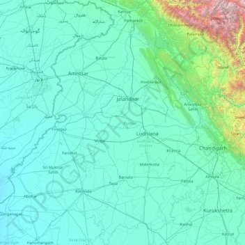
Nombre: Mapa topográfico Panyab, altitud, relieve.
Lugar: Panyab, India (29.54294 73.87983 32.51118 76.93906)
Altitud media: 477 m
Altitud mínima: 170 m
Altitud máxima: 6.027 m
Haz una donación
Otros mapas topográficos
Haga clic en un mapa para ver su topografía, su altitud y su relieve.
Bangalore
India > Karnataka > Bangalore North
Bangalore se encuentra en el sureste de la región meridional del estado indio de Karnataka. Localizada en el corazón de la meseta de Mysore (una región de la gran meseta del Decán) tiene una elevación media de 920 m.
Altitud media: 879 m
Leh
India > Ladaj > Leh Tehsil
Leh fue la antigua capital del reino de Ladakh en los himalayas. Actualmente lo es del distrito de Leh y del territorio de Ladakh, India. En el pueblo aún se destacan las ruinas del palacio de Leh, dicho palacio era la residencia de la familia real de Ladakh, que es similar a una copia reducida del palacio…
Altitud media: 3.653 m
Haz una donación
Haz una donación
Haz una donación
Jaynagar Majilpur
India > Bengala Occidental > Jaynagar - I
Se encuentra a una altitud de 8 m s. n. m. a 49 km de la capital estatal, Calcuta, en la zona horaria UTC +5:30.
Altitud media: 5 m
Haz una donación
Haz una donación