
Gracias por apoyar a este sitio ❤️
Haz una donación
Haz una donación
Mapa topográfico Évora
Haga clic en el mapa para ver la altitud.
Gracias por apoyar a este sitio ❤️
Haz una donación
Haz una donación
Évora
El municipio de Évora se encuentra en medio de la gran llanura del Alentejo, que se caracteriza por una ondulación muy suave y una altitud media de 240 metros. Con una superficie de 1308 km², el municipio ocupa 5 % de la superficie de Alentejo. El área urbana cubre 1643 ha. Sus coordenadas aproximadas son 38º 34' N de latitud y 007º 54' O de longitud.
Gracias por apoyar a este sitio ❤️
Haz una donación
Haz una donación
Acerca de este mapa
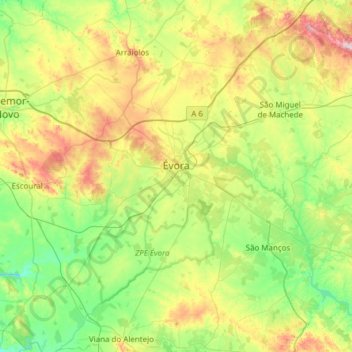
Nombre: Mapa topográfico Évora, altitud, relieve.
Lugar: Évora, Portugal (38.34068 -8.16570 38.76820 -7.55494)
Altitud media: 247 m
Altitud mínima: 112 m
Altitud máxima: 550 m
Gracias por apoyar a este sitio ❤️
Haz una donación
Haz una donación
Otros mapas topográficos
Haga clic en un mapa para ver su topografía, su altitud y su relieve.
Foros do Baldio
Portugal > Évora > Nossa Senhora da Vila, Nossa Senhora do Bispo e Silveiras
Altitud media: 201 m