
Gracias por apoyar a este sitio ❤️
Haz una donación
Haz una donación
Mapa topográfico Maui
Haga clic en el mapa para ver la altitud.
Gracias por apoyar a este sitio ❤️
Haz una donación
Haz una donación
Maui
Maui es una isla formada por dos volcanes que se unen en un istmo. El volcán más antiguo es el Mauna Kahalawai que está muy erosionado y también se llama West Maui Mountain. Al este está el Haleakala, un volcán más joven y más grande con una caldera a 3050 metros de altitud. La última erupción fue en 1790.
Gracias por apoyar a este sitio ❤️
Haz una donación
Haz una donación
Acerca de este mapa
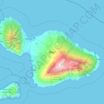
Nombre: Mapa topográfico Maui, altitud, relieve.
Lugar: Maui, Condado de Maui, Hawái, Estados Unidos de América (20.57443 -156.69726 21.03156 -155.97909)
Altitud media: 232 m
Altitud mínima: -4 m
Altitud máxima: 3.044 m
Gracias por apoyar a este sitio ❤️
Haz una donación
Haz una donación