
Mapa topográfico Harbin
Mapa interactivo
Haga clic en el mapa para ver la altitud.
Harbin
Harbin, con una superficie total de 53 068 km², se encuentra en el sur de la provincia de Heilongjiang y es la capital provincial. La prefectura está también situada en el borde suroriental de la llanura de Songnen (松嫩 平原), una parte importante de la llanura noreste de China. El centro de la ciudad también se encuentra en la orilla sur del río Songhua. Harbin recibió su apodo de «La perla en el cuello del cisne» ya que la forma de Heilongjiang se asemeja a un cisne. Su área administrativa es bastante grande con la latitud que abarca 44° 04′−46° 40′ N, y longitud 125° 42′−130° 10' E. Las ciudades vecinas del prefecto-nivel son Yichun al norte, Jiamusi y Qitaihe al noreste, Mudanjiang al sureste, Daqing al oeste y Suihua al noroeste. En su frontera suroeste está la provincia de Jilin. El terreno principal de la ciudad es generalmente plano y bajo, con una elevación media de alrededor 150 metros. Sin embargo, el territorio que comprende las 10 divisiones a nivel de condado en la parte oriental del municipio consiste en montañas y tierras altas. La parte más oriental de la prefectura de Harbin también tiene humedales extensos, sobre todo en el condado de Yilan que está situado en el borde al sudoeste de la llanura de Sanjiang.
Acerca de este mapa
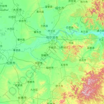
Nombre: Mapa topográfico Harbin, altitud, relieve.
Lugar: Harbin, Heilongjiang, China (44.05998 125.67825 46.67182 130.23350)
Altitud media: 250 m
Altitud mínima: 100 m
Altitud máxima: 1.687 m