
Mapa topográfico Gap
Mapa interactivo
Haga clic en el mapa para ver la altitud.
Acerca de este mapa
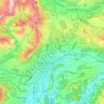
Nombre: Mapa topográfico Gap, altitud, relieve.
Altitud media: 1.146 m
Altitud mínima: 629 m
Altitud máxima: 2.374 m
Otros mapas topográficos
Haga clic en un mapa para ver su topografía, su altitud y su relieve.
Torrent de Chichin
Francia > Provenza-Alpes-Costa Azul > Altos Alpes > Freissinières > Dormillouse
Altitud media: 1.979 m
Col de la Traversette / Colle Delle Traversette
Francia > Provenza-Alpes-Costa Azul > Altos Alpes > Abriès-Ristolas
Altitud media: 2.683 m