Mapa topográfico Sikkim
Haga clic en el mapa para ver la altitud.
Sikkim
La media anual del estado está en 18 °C. Sikkim es uno de los pocos Estados de la India que recibe abundantes precipitaciones en forma de nieve. El límite de nieve está en los seis mil metros de altitud. Durante los meses del monzón, caen abundantes precipitaciones aumentando el número de deslizamientos de tierra.
Acerca de este mapa
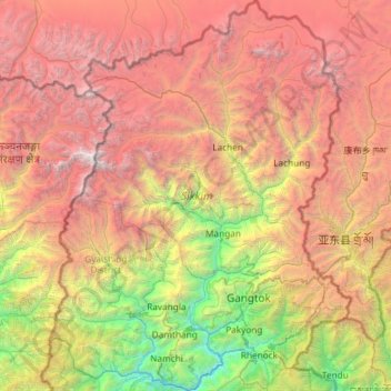
Nombre: Mapa topográfico Sikkim, altitud, relieve.
Lugar: Sikkim, India (27.07926 88.01203 28.12405 88.92117)
Altitud media: 3.786 m
Altitud mínima: 264 m
Altitud máxima: 8.434 m
Otros mapas topográficos
Haga clic en un mapa para ver su topografía, su altitud y su relieve.
Muzaffarpur
Se encuentra a una altitud de 58 m s. n. m. a 74 km de la capital estatal, Patna, en la zona horaria UTC +5:30.
Altitud media: 54 m
Pune
India > Maharastra > Pune City Subdistrict
Pune se encuentra a 560 m (1.840 pies) sobre el nivel del mar, en la margen occidental de la meseta de Deccan. Está situado en el lado de sotavento de la cordillera Sahyadri, que forma una barrera desde el mar Arábigo. Es una ciudad montañosa, con su colina más alta, Vetal Hill, subirán 800 m (2600 pies)…
Altitud media: 641 m




Pasighat
India > Arunachal Pradesh > Pasighat HQ
Se encuentra a una altitud de 180 m s. n. m. a 335 km de la capital estatal, Itanagar, en la zona horaria UTC +5:30.
Altitud media: 179 m
Bombay
Bombay se encuentra en la costa del mar Arábigo en el oeste de la India. La altitud media de la ciudad es de 11 m sobre el nivel del mar.
Altitud media: 13 m


Bombay
Bombay se encuentra en la costa del mar Arábigo en el oeste de la India. La altitud media de la ciudad es de 11 m sobre el nivel del mar.
Altitud media: 13 m
Pune
India > Maharastra > Pune City Subdistrict
Pune se encuentra a 560 m (1.840 pies) sobre el nivel del mar, en la margen occidental de la meseta de Deccan. Está situado en el lado de sotavento de la cordillera Sahyadri, que forma una barrera desde el mar Arábigo. Es una ciudad montañosa, con su colina más alta, Vetal Hill, subirán 800 m (2600 pies)…
Altitud media: 641 m
Pune
India > Maharastra > Pune City Subdistrict
Pune se encuentra a 560 m (1.840 pies) sobre el nivel del mar, en la margen occidental de la meseta de Deccan. Está situado en el lado de sotavento de la cordillera Sahyadri, que forma una barrera desde el mar Arábigo. Es una ciudad montañosa, con su colina más alta, Vetal Hill, subirán 800 m (2600 pies)…
Altitud media: 641 m
Bombay
Bombay se encuentra en la costa del mar Arábigo en el oeste de la India. La altitud media de la ciudad es de 11 m sobre el nivel del mar.
Altitud media: 13 m
Pune
India > Maharastra > Pune City Subdistrict
Pune se encuentra a 560 m (1.840 pies) sobre el nivel del mar, en la margen occidental de la meseta de Deccan. Está situado en el lado de sotavento de la cordillera Sahyadri, que forma una barrera desde el mar Arábigo. Es una ciudad montañosa, con su colina más alta, Vetal Hill, subirán 800 m (2600 pies)…
Altitud media: 641 m
Pune
India > Maharastra > Pune City Subdistrict
Pune se encuentra a 560 m (1.840 pies) sobre el nivel del mar, en la margen occidental de la meseta de Deccan. Está situado en el lado de sotavento de la cordillera Sahyadri, que forma una barrera desde el mar Arábigo. Es una ciudad montañosa, con su colina más alta, Vetal Hill, subirán 800 m (2600 pies)…
Altitud media: 641 m
Bombay
Bombay se encuentra en la costa del mar Arábigo en el oeste de la India. La altitud media de la ciudad es de 11 m sobre el nivel del mar.
Altitud media: 13 m
Pune
India > Maharastra > Pune City Subdistrict
Pune se encuentra a 560 m (1.840 pies) sobre el nivel del mar, en la margen occidental de la meseta de Deccan. Está situado en el lado de sotavento de la cordillera Sahyadri, que forma una barrera desde el mar Arábigo. Es una ciudad montañosa, con su colina más alta, Vetal Hill, subirán 800 m (2600 pies)…
Altitud media: 641 m
Bombay
Bombay se encuentra en la costa del mar Arábigo en el oeste de la India. La altitud media de la ciudad es de 11 m sobre el nivel del mar.
Altitud media: 13 m
Pune
India > Maharastra > Pune City Subdistrict
Pune se encuentra a 560 m (1.840 pies) sobre el nivel del mar, en la margen occidental de la meseta de Deccan. Está situado en el lado de sotavento de la cordillera Sahyadri, que forma una barrera desde el mar Arábigo. Es una ciudad montañosa, con su colina más alta, Vetal Hill, subirán 800 m (2600 pies)…
Altitud media: 641 m
Purnia
India > Bihar > Purnia East
Se encuentra a una altitud de 41 m s. n. m. a 305 km de la capital estatal, Patna, en la zona horaria UTC +5:30.
Altitud media: 38 m
Chikkamagaluru
India > Karnataka > Chikkamagaluru taluku
Se encuentra a una altitud de 714 m s. n. m. a 181 km de la capital estatal, Bangalore, en la zona horaria UTC +5:30.
Altitud media: 1.052 m
Dwarka
India > Guyarat > Okhamandal Taluka
Se encuentra a una altitud de 138 m s. n. m. en la desembocadura del río Gomti, a 463 km de la capital estatal, Gandhinagar. En el extremo noroccidental de la península de Kathiawar. Localizada en la zona horaria IST UTC+05:30.
Altitud media: 3 m








Ahmedabad
Ahmedabad se localiza en la India occidental, a una altitud de 53 m sobre el nivel medio del mar. Se localiza al margen del río Sabarmati, en la región central-norte del estado. Cubre una superficie de 205 km². El Sabarmati secciona la ciudad en dos, una parte oriental y la otra occidental. El río se seca…
Altitud media: 50 m


Muzaffarpur
Se encuentra a una altitud de 58 m s. n. m. a 74 km de la capital estatal, Patna, en la zona horaria UTC +5:30.
Altitud media: 54 m
Leh
Leh fue la antigua capital del reino de Ladakh en los himalayas. Actualmente lo es del distrito de Leh y del territorio de Ladakh, India. En el pueblo aún se destacan las ruinas del palacio de Leh, dicho palacio era la residencia de la familia real de Ladakh, que es similar a una copia reducida del palacio…
Altitud media: 4.294 m




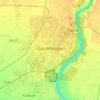
Gandhinagar
India > Guyarat > Gandhinagar Taluka
Gandhinagar tiene una elevación promedio de 81 metros. La ciudad se encuentra en las orillas del río Sabarmati. Los 20 543 km² alrededor de Gandhinagar se define por tramos en el territorio guyaratí. Tiene un área de 205 km² (79.15 millas cuadradas). El río se seca con frecuencia en el verano, dejando…
Altitud media: 75 m




Leh
Leh fue la antigua capital del reino de Ladakh en los himalayas. Actualmente lo es del distrito de Leh y del territorio de Ladakh, India. En el pueblo aún se destacan las ruinas del palacio de Leh, dicho palacio era la residencia de la familia real de Ladakh, que es similar a una copia reducida del palacio…
Altitud media: 3.653 m
Memari
India > Bengala Occidental > Memari - I
Se encuentra a una altitud de 26 m s. n. m. a 89 km de la capital estatal, Calcuta, en la zona horaria UTC +5:30.
Altitud media: 21 m









Gaya
India > Bihar > Gaya Town C.D.Block
Se encuentra a una altitud de 121 m s. n. m. a 102 km de la capital estatal, Patna, en la zona horaria UTC +5:30.
Altitud media: 111 m

Nellore
India > Andhra Pradesh > Nellore
Se encuentra a una altitud de 32 m s. n. m. a 456 km de la capital estatal, Hyderabad, en la zona horaria UTC +5:30.
Altitud media: 17 m