
Mapa topográfico Airdrie
Haga clic en el mapa para ver la altitud.
Airdrie
El origen del nombre de Airdrie apareció por primera vez en el Registro del Gran Sello de Escocia (Registrum Magni Sigilii Regum Scotorum) en 1373 como Ardre. Para 1546 se había convertido en Ardry y para 1587 era conocido como Ardrie. En 1630 apareció finalmente en el Registro como Airdrie. Dada la topografía de la zona, la interpretación más probable es que el nombre se derive del gaélico An Àrd Ruigh que significa una altura plana o un terreno de pasto alto. Otra posibilidad es que sea del gaélico An Àrd Àirighe que significa un cobertizo, un pasto de verano/cabaña de pastor. Una tercera posibilidad es el Ard Reidh gaélico que significa una llanura alta. Otra alternativa no gaélica es el Brythonic, es decir, Cumbric o North Welsh, ard tref (que se convierte en ardre por proceso de asimilación), que significa un alto camino o granja, que se remontaría a los tiempos del Reino de Strathclyde, antes de la expansión del habla gaélica o inglesa en la región. El castillo de Airthrey en Stirlingshire puede tener una derivación similar.
Acerca de este mapa
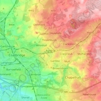
Nombre: Mapa topográfico Airdrie, altitud, relieve.
Lugar: Airdrie, North Lanarkshire, Escocia, ML6 6BU, Reino Unido (55.82578 -4.01959 55.90578 -3.93959)
Altitud media: 136 m
Altitud mínima: 48 m
Altitud máxima: 228 m