
Mapa topográfico Santiago de Compostela
Mapa interactivo
Haga clic en el mapa para ver la altitud.
Santiago de Compostela
El relieve del municipio se caracteriza por una sucesión de montes entre los valles de los ríos Sar y Sarela. Además, el río Tambre hace de límite septentrional del territorio. La altitud oscila entre los 530 metros (monte Espiñeira) y los 70 metros a orillas del Sar. La ciudad se alza a 258 metros sobre el nivel del mar.
Acerca de este mapa
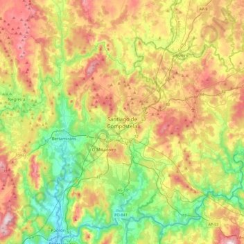
Nombre: Mapa topográfico Santiago de Compostela, altitud, relieve.
Altitud media: 248 m
Altitud mínima: 2 m
Altitud máxima: 596 m
Otros mapas topográficos
Haga clic en un mapa para ver su topografía, su altitud y su relieve.
Santiago de Compostela
España > Galicia > Santiago > Santiago de Compostela
El relieve del municipio se caracteriza por una sucesión de montes entre los valles de los ríos Sar y Sarela. Además, el río Tambre hace de límite septentrional del territorio. La altitud oscila entre los 530 metros (monte Espiñeira) y los 70 metros a orillas del Sar. La ciudad se alza a 258 metros sobre…
Altitud media: 260 m
Boqueixón
El relieve del municipio está configurado por una sucesión de valles y colinas que descienden hacia el río Ulla, que hace de límite con la provincia de Pontevedra. Su topografía se caracteriza por su suavidad, rompiendo esta tendencia en algunos sectores con formas más abruptas y escarpadas. Esto sucede…
Altitud media: 250 m
Brión
Boullón debe su nombre a un hidrónimo prerromano: significaría "sitio donde nace agua burbujeante". Cornanda también tiene origen prerromano, haría referencia al hecho de que la parroquia esté situada en una elevación. A Luaña es un topónimo prerromano que estaría relacionado con las aguas.
Altitud media: 211 m
Vedra
Integrado en la comarca de Santiago, se sitúa a 87 kilómetros de la capital provincial. Forma parte de la comarca natural del valle del Ulla (en gallego Val do Ulla) o simplemente comarca del Ulla. Tiene una extensión de 52 km², de relieve suave cuyo punto más elevado es el de Penas Pardas (449…
Altitud media: 167 m