Geolocalizar

Mapa topográfico Queensland

Haga clic en el mapa para ver la altitud.

Queensland

Queensland's topography is characterized by a diverse landscape that includes coastal plains, mountain ranges, plateaus, and expansive inland areas. The Great Dividing Range runs parallel to the state's eastern coast, forming a series of mountain ranges, plateaus, and upland areas. This range influences the climate and hydrology of the region, acting as a watershed that directs river systems either toward the Pacific Ocean or inland areas. The coastal region east of the range features fertile plains and river valleys, supporting agriculture and dense population centers. In contrast, the western side transitions into arid and semi-arid landscapes, characterized by vast plains and low-relief areas. Notably, the Wet Tropics of Queensland, stretching from Townsville to Cooktown, encompasses rugged terrains with highlands, tablelands, and escarpments, including Australia's highest waterfall, Wallaman Falls. The state's highest peak, Mount Bartle Frere, rises to 1,622 meters (5,321 feet) in this region. Additionally, Queensland's coastline is adorned with significant sand islands such as K'gari (Fraser Island), Moreton, and North Stradbroke, with K'gari being the largest sand island globally.

Acerca de este mapa

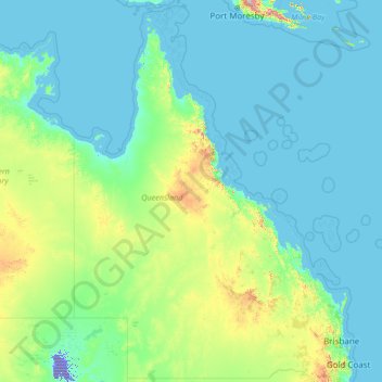
Nombre: Mapa topográfico Queensland, altitud, relieve.

Lugar: Queensland, Australia (-29.17927 137.99465 -9.08801 153.61160)

Altitud media: 122 m

Altitud mínima: -16 m

Altitud máxima: 3.313 m

Otros mapas topográficos

Haga clic en un mapa para ver su topografía, su altitud y su relieve.

Perth

Australia > Western Australia

Perth, the capital of Western Australia, is situated on the Swan Coastal Plain, a flat expanse of sandy soil nestled between the Indian Ocean to the west and the Darling Scarp to the east. The Darling Scarp, also known as the Darling Range, is a low escarpment that extends north–south, marking a distinct…

Altitud media: 26 m

Brisbane

Australia > Queensland > Brisbane

Altitud media: 45 m

Canberra

Australia

The area chosen for the capital had been inhabited by Indigenous Australians for up to 21,000 years, with the principal group being the Ngunnawal people. European settlement commenced in the first half of the 19th century, as evidenced by surviving landmarks such as St John's Anglican Church and Blundells…

Altitud media: 638 m

Adelaide

Australia > South Australia > Adelaide

Adelaide is north of the Fleurieu Peninsula, on the Adelaide Plains between the Gulf St Vincent and the low-lying Mount Lofty Ranges. The city stretches 20 km (12 mi) from the coast to the foothills, and 90 km (56 mi) from Gawler at its northern extent to Sellicks Beach in the south. According to the Regional…

Altitud media: 148 m

Gold Coast

Australia > Queensland

Altitud media: 42 m

Great Dividing Range

Australia

The Great Dividing Range, also known as the East Australian Cordillera or the Eastern Highlands, is a cordillera system in eastern Australia consisting of an expansive collection of mountain ranges, plateaus and rolling hills, that runs roughly parallel to the east coast of Australia and forms the…

Altitud media: 117 m

Sunshine Coast

Australia > Queensland > Sunshine Coast Regional

The Sunshine Coast in Queensland, Australia, showcases a diverse topography that harmoniously blends coastal plains with rugged hinterlands. Along its eastern edge, the region features expansive sandy beaches and coastal dunes that transition smoothly into fertile lowlands. Inland, the terrain becomes more…

Altitud media: 109 m

Ballarat

Australia > Victoria

Ballarat has a moderate oceanic climate (Köppen climate classification Cfb) with four distinct seasons. Its elevation, ranging between 400 and 630 metres (1,310 and 2,070 feet) above sea level, causes its mean monthly temperatures to tend to be on average 3 to 5 °C (5 to 9 °F) below those of Melbourne,…

Altitud media: 470 m

Hervey Bay

Australia > Queensland

Altitud media: 6 m

Toowoomba

Australia > Queensland

The city occupies the edge of the range and the low ridges behind it. Two valleys run north from the southern boundary, each arising from springs either side of Middle Ridge near Spring Street at an altitude of around 680 m. These waterways, East Creek and West Creek, flow together just north of the CBD to…

Altitud media: 458 m

Ipswich

Australia > Queensland > Ipswich

Altitud media: 73 m

Mackay

Australia > Queensland

Altitud media: 13 m

Cairns

Australia > Queensland

South of Smithfield and inland from the Northern Beaches along the edge of the Barron River flood plain are the suburbs of Caravonica, Kamerunga, Freshwater, and Stratford. This area is sometimes referred to as Freshwater Valley, though it is actually the lower part of Redlynch Valley; further up the valley…

Altitud media: 176 m

Mount Banks

Australia > New South Wales

Mount Banks, otherwise known as Mount King George, is a mountain within the Explorers Range of the Blue Mountains Range that is a spur off the Great Dividing Range, is located within the Blue Mountains National Park, approximately 100 kilometres (62 mi) west of Sydney in New South Wales, Australia. Mount Banks…

Altitud media: 745 m

Sydney

Australia > New South Wales

Phillip had been given no instructions for urban development, but in July 1788 submitted a plan for the new town at Sydney Cove. It included a wide central avenue, a permanent Government House, law courts, hospital and other public buildings, but no provision for warehouses, shops, or other commercial…

Altitud media: 32 m

Newcastle

Australia > New South Wales

Altitud media: 9 m

Melbourne

Australia > Victoria

Melbourne is also prone to isolated convective showers forming when a cold pool crosses the state, especially if there is considerable daytime heating. These showers are often heavy and can include hail, squalls, and significant drops in temperature, but they often pass through very quickly with a rapid…

Altitud media: 49 m

Dubbo

Australia > New South Wales > Dubbo

Altitud media: 307 m

Canberra

Australia

The area chosen for the capital had been inhabited by Indigenous Australians for up to 21,000 years, with the principal group being the Ngunnawal people. European settlement commenced in the first half of the 19th century, as evidenced by surviving landmarks such as St John's Anglican Church and Blundells…

Altitud media: 638 m

Mandurah

Australia > Western Australia

Altitud media: 5 m

Sydney Bay

Australia

Altitud media: 15 m

Nourlangie Creek

Australia

Altitud media: 12 m

Mount Macedon

Australia > Victoria

Altitud media: 755 m

Darwin

Australia > City of Darwin

Altitud media: 8 m

Katherine Gorge

Australia

Altitud media: 145 m

Cotton Vale

Australia > Queensland

Altitud media: 914 m

Uluru

Australia

Altitud media: 596 m

Heathcote

Australia > Victoria > Heathcote

Altitud media: 261 m

Geelong

Australia > Victoria

Altitud media: 42 m

Glenlyon

Australia > Victoria

Altitud media: 561 m

Allans Flat

Australia > Victoria

Altitud media: 223 m

Govetts Leap

Australia > New South Wales

Altitud media: 902 m

Corin Dam

Australia

Altitud media: 1.043 m

Many Peaks

Australia > Queensland

Altitud media: 194 m

New Gisborne

Australia > Victoria

Altitud media: 460 m

Paynesville

Australia > Victoria

Altitud media: 5 m

Bribie Island

Australia > Queensland

Altitud media: 44 m

Snowy Mountains

Australia > New South Wales

Altitud media: 2.011 m

Riddells Creek

Australia > Victoria

Altitud media: 450 m

Warragul

Australia > Victoria > Warragul

Altitud media: 133 m

Queanbeyan

Australia > New South Wales

Altitud media: 716 m

Russell Island

Australia > Queensland

Altitud media: 8 m

Mount Borah

Australia > New South Wales

Altitud media: 657 m

Mount Howitt

Australia > Victoria

Altitud media: 1.467 m

Eucumbene Cove

Australia > New South Wales

Altitud media: 1.211 m

Blue Mountains

Australia > New South Wales

A sandstone plateau dominated by a landscape of endless eucalyptus forests, the Blue Mountains are located at the top of a 470-million-year-old quartzite. In the Permian period, a shallow sea covered the region, when rivers brought shales, siltstones and mudstones. Then during the Mesozoic period, rivers…

Altitud media: 566 m

Mount Dandenong

Australia > Victoria > Melbourne

Mount Dandenong has a cool oceanic climate (Cfb), with cool to mild summers and cold, damp winters. Daytime temperatures are usually 4−6 °C cooler than downtown Melbourne due to its elevation and distance from the urban heat island effect of Melbourne. It is significantly cloudier than Melbourne,…

Altitud media: 395 m

Mount Gravatt

Australia > Queensland

Altitud media: 70 m

Australian Alps

Australia > New South Wales

The Australian Alps are a mountain range in southeast Australia. It comprises an interim Australian bioregion, and is the highest mountain range in Australia. The range straddles the borders of eastern Victoria, southeastern New South Wales, and the Australian Capital Territory. It contains Australia's only…

Altitud media: 2.037 m

Tara

Australia > Queensland > Tara

Altitud media: 314 m

Kempsey

Australia > New South Wales > Kempsey

Altitud media: 15 m

Launceston

Australia > Tasmania > Launceston

Launceston is at 41°26′31″S 147°8′42″E / 41.44194°S 147.14500°E / -41.44194; 147.14500 in the Tamar Valley, Northern Tasmania. The valley was formed by volcanic and glacial forces over 10 million years ago. The city is about 45 kilometres (28 mi) south of the Bass Strait, with its closest…

Altitud media: 218 m

Cowes

Australia > Victoria > Cowes

Altitud media: 12 m

Point Nepean

Australia > Victoria > Melbourne

Altitud media: 1 m

Maitland

Australia > New South Wales > Maitland

Altitud media: 16 m

Mount Lofty

Australia > South Australia

Altitud media: 554 m

Lake Mountain

Australia > Victoria

Altitud media: 1.289 m

Ruffey Lake Park

Australia > Victoria > Melbourne

Altitud media: 89 m

Townsville

Australia > Queensland

Altitud media: 30 m

Queenscliff

Australia > Victoria > Queenscliff

Altitud media: 3 m

Ballarat

Australia > Victoria

Ballarat has a moderate oceanic climate (Köppen climate classification Cfb) with four distinct seasons. Its elevation, ranging between 400 and 630 metres (1,310 and 2,070 feet) above sea level, causes its mean monthly temperatures to tend to be on average 3 to 5 °C (5 to 9 °F) below those of Melbourne,…

Altitud media: 470 m

Karratha

Australia > Western Australia

Altitud media: 19 m

Diamond Creek

Australia > Victoria

Altitud media: 75 m

Ferny Creek

Australia > Victoria

Altitud media: 134 m

Pimpama

Australia > Queensland > Gold Coast > Pimpama

Altitud media: 19 m

Broome

Australia > Western Australia

Altitud media: 8 m

Bundaberg

Australia > Queensland

Altitud media: 18 m

MacDonnell Ranges

Australia

The highest peaks are Mount Zeil with an elevation of 1,531 metres (5,023 ft) AHD, Mount Liebig at 1,524 metres (5,000 ft) AHD, Mount Edward at 1,423 metres (4,669 ft), Mount Giles at 1,389 metres (4,557 ft) and Mount Sonder at 1,380 metres (4,530 ft) AHD; the five highest mountains in the Northern Territory.…

Altitud media: 594 m

Port Stewart

Australia > Queensland

Altitud media: 2 m

Moorabool Reservoir

Australia > Victoria

Altitud media: 609 m

Palm Island

Australia > Queensland

Altitud media: 7 m

Stanley

Australia > Victoria

Altitud media: 756 m

Mount Hay

Australia > New South Wales

Altitud media: 644 m

Yapeen

Australia > Victoria

Altitud media: 289 m

Buxton

Australia > Victoria

Altitud media: 318 m

Neerim South

Australia > Victoria

Altitud media: 215 m

Gosford

Australia > New South Wales

Altitud media: 75 m

Maleny

Australia > Queensland > Maleny

Altitud media: 364 m

Albany

Australia > Western Australia

Altitud media: 30 m

Montville

Australia > Queensland > Montville

Altitud media: 261 m

Bendigo

Australia > Victoria

Altitud media: 223 m