
Mapa topográfico Burton-on-Trent
Mapa interactivo
Haga clic en el mapa para ver la altitud.
Burton-on-Trent
Burton is about 109 miles (175 km) north west of London, about 30 miles north east of Birmingham, the UK's second largest city and about 23 miles east of the county town Stafford. It is at the easternmost border of the county of Staffordshire with Derbyshire, its suburbs and the course of the River Trent forming part of the county boundary. It is also near the south-eastern terminus of the Trent and Mersey Canal. Burton lies within the northern boundary of the National Forest. The town centre is on the western bank of the River Trent in a valley bottom; its average elevation is about 50 metres above sea level; the village of Winshill and the suburb of Stapenhill rise to 130 m and 100 m respectively.
Acerca de este mapa
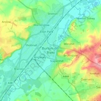
Nombre: Mapa topográfico Burton-on-Trent, altitud, relieve.
Altitud media: 69 m
Altitud mínima: 38 m
Altitud máxima: 149 m