
Mapa topográfico Enchanted Rock
Mapa interactivo
Haga clic en el mapa para ver la altitud.
Acerca de este mapa
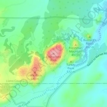
Nombre: Mapa topográfico Enchanted Rock, altitud, relieve.
Lugar: Enchanted Rock, Llano County, Texas, United States (30.50642 -98.81885 30.50652 -98.81875)
Altitud media: 453 m
Altitud mínima: 414 m
Altitud máxima: 554 m
Enchanted Rock is a pink granite mountain located in the Llano Uplift about 17 miles (27 km) north of Fredericksburg, Texas and 24 miles (39 km) south of Llano, Texas, United States. Enchanted Rock State Natural Area, which includes Enchanted Rock and surrounding land, spans the border between Gillespie and Llano counties, south of the Llano River. Enchanted Rock covers roughly 640 acres (260 ha) and rises around 425 feet (130 m) above the surrounding terrain to an elevation of 1,825 feet (556 m) above sea level. It is the largest pink granite monadnock in the United States. Enchanted Rock State Natural Area, a part of the Texas state park system, includes 1,644 acres (665 ha).[4] In 1936, the area was designated a Recorded Texas Historic Landmark.[5] In 1971, Enchanted Rock was designated as a National Natural Landmark by the National Park Service.[6]
Otros mapas topográficos
Haga clic en un mapa para ver su topografía, su altitud y su relieve.
Horseshoe Bay
United States > Texas > Llano County
Horseshoe Bay, Llano County, Texas, 78657, United States
Altitud media: 290 m
Kingsland
United States > Texas > Llano County
Kingsland, Llano County, Texas, 78639, United States
Altitud media: 263 m