
Mapa topográfico Hawkins County
Mapa interactivo
Haga clic en el mapa para ver la altitud.
Acerca de este mapa
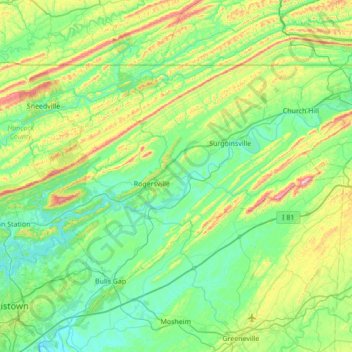
Nombre: Mapa topográfico Hawkins County, altitud, relieve.
Lugar: Hawkins County, East Tennessee, Tennessee, United States (36.24192 -83.28908 36.59411 -82.59999)
Altitud media: 441 m
Altitud mínima: 308 m
Altitud máxima: 901 m
Otros mapas topográficos
Haga clic en un mapa para ver su topografía, su altitud y su relieve.
Pinson Mounds State Archaeological Area
United States > Tennessee > Madison County
Altitud media: 120 m
Millersville City Park
United States > Tennessee > Robertson County > Millersville
Altitud media: 260 m
Douglas Dam
United States > Tennessee > Sevier County > Sevierville
The Douglas Project required the construction of ten smaller, earthen saddle dams to fill in gaps along the adjacent ridgeline and permit a higher water elevation than would otherwise be possible. Most of these saddle dams are located in the hills southeast of the main dam. One protects downtown Dandridge,…
Altitud media: 312 m
Edwin Warner Park
United States > Tennessee > Davidson County > Nashville > Devonshire Manor
Altitud media: 198 m
Barfield Crescent Park
United States > Tennessee > Rutherford County > Murfreesboro
Altitud media: 201 m
Mountain Ridge
United States > Tennessee > Hamilton County > Chattanooga > Red Bank
Altitud media: 249 m