
Mapa topográfico Grand Cayman
Mapa interactivo
Haga clic en el mapa para ver la altitud.
Acerca de este mapa
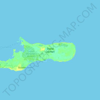
Nombre: Mapa topográfico Grand Cayman, altitud, relieve.
Lugar: Grand Cayman, Cayman Islands (19.26290 -81.42021 19.39685 -81.08468)
Altitud media: 1 m
Altitud mínima: 0 m
Altitud máxima: 16 m
Grand Cayman encompasses 76% of the territory's entire land mass. The island is approximately 22 miles (35 km) long with its widest point being 8 miles (13 km) wide. The elevation ranges from sea level at the beaches to 60 feet (18 m) above sea level on the North Side's Mastic Trail. Unlike many other Caribbean islands, Grand Cayman is for the most part, flat. This allows for more space to build as the island’s population grows.
Otros mapas topográficos
Haga clic en un mapa para ver su topografía, su altitud y su relieve.
Beach Bay
Cayman Islands > South Cayman Palms
Beach Bay, South Cayman Palms, KY1-1105, Cayman Islands
Altitud media: 4 m
Whitehall Estate
Whitehall Estate, West Bay, KY1-1202, Cayman Islands
Altitud media: 3 m
Little Cayman
Little Cayman, Sister Islands, KY3-2501, Cayman Islands
Altitud media: 1 m
Northward
Cayman Islands > Bodden Town > Northward
Northward, Bodden Town, KY1-1105, Cayman Islands
Altitud media: 6 m
Cork Landing
Cork Landing, Sister Islands, Cayman Islands
Altitud media: 2 m
Drift Wood Village
Cayman Islands > Drift Wood Village
Drift Wood Village, Cayman Islands
Altitud media: 2 m