
Mapa topográfico Wichita
Mapa interactivo
Haga clic en el mapa para ver la altitud.
Acerca de este mapa
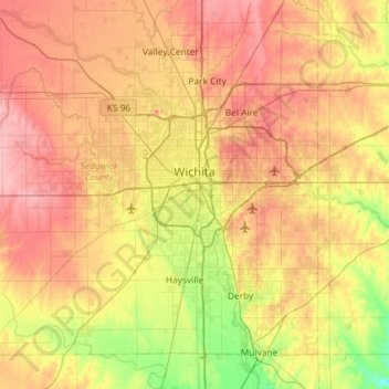
Nombre: Mapa topográfico Wichita, altitud, relieve.
Lugar: Wichita, Sedgwick County, Kansas, United States (37.48902 -97.73435 37.84020 -97.15300)
Altitud media: 408 m
Altitud mínima: 355 m
Altitud máxima: 459 m
The city lies on the Arkansas River near the western edge of the Flint Hills in the Wellington-McPherson Lowlands region of the Great Plains. The area's topography is characterized by the broad alluvial plain of the Arkansas River valley and the moderately rolling slopes that rise to the higher lands on either side.
Otros mapas topográficos
Haga clic en un mapa para ver su topografía, su altitud y su relieve.
Haysville
United States > Kansas > Sedgwick County
Haysville, Sedgwick County, Kansas, United States
Altitud media: 388 m
Bentley
United States > Kansas > Sedgwick County
Bentley, Sedgwick County, Kansas, United States
Altitud media: 424 m
Wichita
United States > Kansas > Sedgwick County > Wichita
Wichita, Sedgwick County, Kansas, 67202, United States
Altitud media: 410 m
Derby
United States > Kansas > Sedgwick County > Derby
Derby, Sedgwick County, Kansas, United States
Altitud media: 392 m