
Mapa topográfico Ladakh
Mapa interactivo
Haga clic en el mapa para ver la altitud.
Acerca de este mapa
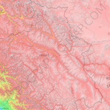
Nombre: Mapa topográfico Ladakh, altitud, relieve.
Lugar: Ladakh, India (32.33574 75.32697 35.67455 79.46075)
Altitud media: 4.726 m
Altitud mínima: 337 m
Altitud máxima: 7.470 m
The Kargil War of 1999, codenamed "Operation Vijay" by the Indian Army, saw infiltration by Pakistani troops into parts of Western Ladakh, namely Kargil, Dras, Mushkoh, Batalik and Chorbatla, overlooking key locations on the Srinagar-Leh highway. Extensive operations were launched in high altitudes by the Indian Army with considerable artillery and air force support. Pakistani troops were evicted from the Indian side of the Line of Control which the Indian government ordered was to be respected and which was not crossed by Indian troops. The Indian government was criticised by the Indian public because India respected geographical co-ordinates more than India's opponents: Pakistan and China.
Otros mapas topográficos
Haga clic en un mapa para ver su topografía, su altitud y su relieve.
Bengaluru
India > Karnataka > Bangalore North
Bengaluru, Bangalore North, Bengaluru Urban District, Karnataka, India
Altitud media: 881 m
3d
India > Rajasthan > Ganganagar Tehsil > 1 LNP
3d, 1 LNP, Ganganagar Tehsil, Sri Ganganagar District, Rajasthan, India
Altitud media: 178 m
North Sentinel Island
India > Andaman and Nicobar Islands > Ferrargunj
North Sentinel Island, Ferrargunj, South Andaman District, Andaman and Nicobar Islands, India
Altitud media: 20 m
Kottakombur
Kottakombur, Devikulam, Idukki District, Kerala, India
Altitud media: 1.919 m
Prayagraj
India > Uttar Pradesh > Prayagraj
Prayagraj, Prayagraj District, Uttar Pradesh, 211001, India
Altitud media: 91 m
Gurgaon
India > Haryana > Gurugram District
Gurgaon, Gurugram District, Haryana, India
Altitud media: 237 m
Mat
India > Uttar Pradesh > Mathura District
Mat, Mathura District, Uttar Pradesh, India
Altitud media: 182 m
Mysuru
India > Karnataka > Mysuru taluk
Mysuru, Mysuru taluk, Mysuru District, Karnataka, 570001, India
Altitud media: 727 m
Akpa
India > Himachal Pradesh > Moorang
Akpa, Moorang, Kinnaur District, Himachal Pradesh, 172116, India
Altitud media: 2.709 m
Bachupally mandal
Bachupally mandal, Medchal–Malkajgiri District, Telangana, 500090, India
Altitud media: 593 m
Western Ghats
Western Ghats, Idukki, Kerala, 685614, India
Altitud media: 2.225 m
Maduranthakam
Maduranthakam, Chengalpattu District, Tamil Nadu, India
Altitud media: 37 m
Thiruvananthapuram
India > Kerala > Thiruvananthapuram
Thiruvananthapuram, Thiruvananthapuram District, Kerala, 695001, India
Altitud media: 33 m
Vijayawada
India > Andhra Pradesh > Vijayawada (Urban)
Vijayawada, Vijayawada (Urban), NTR District, Andhra Pradesh, 520001, India
Altitud media: 36 m
Indore
India > Madhya Pradesh > Juni Indore Tahsil
Indore, Juni Indore Tahsil, Indore District, Madhya Pradesh, 452001, India
Altitud media: 555 m
Pune
India > Maharashtra > Pune City > Pune
Pune, Pune City, Pune District, Maharashtra, 411001, India
Altitud media: 641 m
Walmara
India > Uttarakhand > Syalde
Walmara, Syalde, Almora District, Uttarakhand, 263661, India
Altitud media: 1.043 m
Thuneri
India > Tamil Nadu > Udhagamandalam
Thuneri, Udhagamandalam, Nilgiris District, Tamil Nadu, 643402, India
Altitud media: 1.899 m
Tharangambadi
Tharangambadi, Mayiladuthurai District, Tamil Nadu, India
Altitud media: 5 m
Hosur
India > Tamil Nadu > Hosur
Hosur, Krishnagiri District, Tamil Nadu, 635109, India
Altitud media: 859 m