
Mapa topográfico Champlin
Mapa interactivo
Haga clic en el mapa para ver la altitud.
Champlin
The average elevation is 875 feet (267 m) above sea level, and the Mississippi River is approximately one-eighth of a mile wide throughout Champlin.
Acerca de este mapa
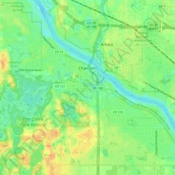
Nombre: Mapa topográfico Champlin, altitud, relieve.
Lugar: Champlin, Hennepin County, Minnesota, 55316, United States (45.15133 -93.42244 45.21152 -93.32840)
Altitud media: 265 m
Altitud mínima: 251 m
Altitud máxima: 283 m
Otros mapas topográficos
Haga clic en un mapa para ver su topografía, su altitud y su relieve.
Mississippi River
United States > Minnesota > Hennepin County > Minneapolis
The uppermost lock and dam on the Upper Mississippi River is the Upper St. Anthony Falls Lock and Dam in Minneapolis. Above the dam, the river's elevation is 799 feet (244 m). Below the dam, the river's elevation is 750 feet (230 m). This 49-foot (15 m) drop is the largest of all the Mississippi River locks…
Altitud media: 256 m
Eden Prairie
United States > Minnesota > Hennepin County > Eden Prairie > Eden Prairie
Altitud media: 267 m