
Mapa topográfico Coral Gables
Mapa interactivo
Haga clic en el mapa para ver la altitud.
Acerca de este mapa
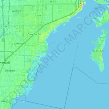
Nombre: Mapa topográfico Coral Gables, altitud, relieve.
Lugar: Coral Gables, Miami-Dade County, Florida, United States (25.60999 -80.30130 25.77177 -80.19563)
Altitud media: 5 m
Altitud mínima: -1 m
Altitud máxima: 32 m
Otros mapas topográficos
Haga clic en un mapa para ver su topografía, su altitud y su relieve.
Hibiscus Point Mobile Home Park
United States > Florida > Miami-Dade County > Hialeah
Altitud media: 8 m
West Little River
United States > Florida > Miami-Dade County > Miami > West Little River
Altitud media: 7 m
Strawberry Village Trailer Park
United States > Florida > Miami-Dade County > Hialeah
Altitud media: 6 m
Miami
United States > Florida > Miami-Dade County
Miami and its suburbs are located on a broad plain between the Everglades to the west and Biscayne Bay to the east, which extends from Lake Okeechobee southward to Florida Bay. The elevation of the area averages at around 6 ft (1.8 m) above sea level in most neighborhoods, especially near the coast. The…
Altitud media: 4 m
Key Biscayne
United States > Florida > Miami-Dade County
Key Biscayne lies south of Miami Beach and east of Miami. The village is connected to Miami via the Rickenbacker Causeway, originally built in 1947. Because of its low elevation and direct exposure to the Atlantic Ocean, it is usually among the first Miami areas to be evacuated before an oncoming hurricane.
Altitud media: 3 m
South Miami Heights
United States > Florida > Miami-Dade County > South Miami Heights
Altitud media: 6 m
Strawberry Village Trailer Park
United States > Florida > Miami-Dade County > Hialeah
Altitud media: 6 m