
Mapa topográfico Brownsville
Mapa interactivo
Haga clic en el mapa para ver la altitud.
Acerca de este mapa
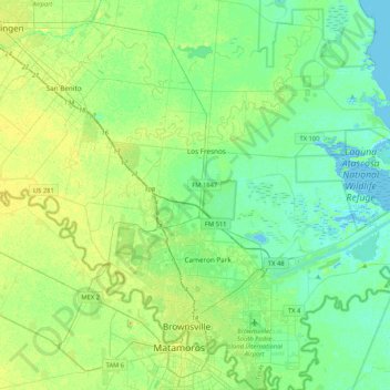
Nombre: Mapa topográfico Brownsville, altitud, relieve.
Lugar: Brownsville, Cameron County, Texas, United States (25.84019 -97.64455 26.21751 -97.27364)
Altitud media: 9 m
Altitud mínima: -3 m
Altitud máxima: 25 m
Soils are mostly of clay to silty clay loam texture, moderately alkaline (pH 8.2) to strongly alkaline (pH 8.5 and with a significant degree of salinity in many places; other types of soils present around the city include Cameron clay and sporadic amounts of Laredo silt loam. Due to Brownsville's proximity to the coast, Lomalta clay is common around the swamp areas of the vicinity. Several parts of the city have a high risk of localized flooding because of flat topography, ubiquitous low-permeability clay soils, and inadequate infrastructure funding.
Otros mapas topográficos
Haga clic en un mapa para ver su topografía, su altitud y su relieve.
Lozano
United States > Texas > Cameron County
Lozano, Cameron County, Texas, United States
Altitud media: 10 m
Bayview
United States > Texas > Cameron County
Bayview, Cameron County, Texas, United States
Altitud media: 7 m
Loma Plata
United States > Texas > Cameron County
Loma Plata, Cameron County, Texas, United States
Altitud media: 0 m
City of Harlingen Dam
United States > Texas > Cameron County > Harlingen
City of Harlingen Dam, Harlingen, Cameron County, Texas, 78552, United States
Altitud media: 15 m
Port Isabel
United States > Texas > Cameron County
Port Isabel, Cameron County, Texas, 78578, United States
Altitud media: 2 m
Harlingen
United States > Texas > Cameron County
Harlingen, Cameron County, Texas, 78550, United States
Altitud media: 14 m
Harlingen
United States > Texas > Cameron County > Harlingen
Harlingen, Cameron County, Texas, 78550, United States
Altitud media: 14 m
South Padre Island
United States > Texas > Cameron County
South Padre Island, Cameron County, Texas, 78597, United States
Altitud media: 0 m
Valle Verde Colonia
United States > Texas > Cameron County > La Feria > Valle Verde Colonia
Valle Verde Colonia, La Feria, Cameron County, Texas, 78559, United States
Altitud media: 19 m