
Haz una donación
Mapa topográfico Muskoka District
Haga clic en el mapa para ver la altitud.
Haz una donación
Acerca de este mapa
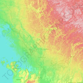
Nombre: Mapa topográfico Muskoka District, altitud, relieve.
Lugar: Muskoka District, Central Ontario, Ontario, Canada (44.76708 -80.59995 45.53394 -78.84341)
Altitud media: 294 m
Altitud mínima: 172 m
Altitud máxima: 555 m
Haz una donación
Otros mapas topográficos
Haga clic en un mapa para ver su topografía, su altitud y su relieve.
Toronto
Despite its deep ravines, Toronto is not remarkably hilly, but its elevation does increase steadily away from the lake. Elevation differences range from 76.5 metres (251 ft) above sea level at the Lake Ontario shore to 209 m (686 ft) ASL near the York University grounds in the city's north end at the…
Altitud media: 113 m
London
Canada > Ontario > London > London
London has a humid continental climate (Köppen Dfb), though due to its downwind location relative to Lake Huron and elevation changes across the city, it is virtually on the Dfa/Dfb (hot summer) boundary favouring the former climate zone to the southwest of the confluence of the South and North Thames Rivers,…
Altitud media: 268 m
Guelph
This region of Ontario has cold winters and warm, humid summers, falling into the Köppen climate classification Dfb zone, with moderately high rainfall and snowfall. It is generally a couple of degrees cooler than lower elevation regions on the Great Lakes shorelines, especially so in winter, the exception…
Altitud media: 344 m
Haz una donación
Peterborough
Canada > Ontario > Peterborough
Peterborough's topography is largely defined by land formations created by the receding Wisconsian glaciers 10,000–15,000 years ago. The South End and Downtown portions of the City sit on what was the bottom of the glacial Lake Peterborough—part of a glacial spillway created when glacial meltwaters from…
Altitud media: 235 m
Haz una donación
Haz una donación
Key River
Canada > Ontario > Parry Sound District > Unorganized Centre Parry Sound
Altitud media: 194 m
Haz una donación
Haz una donación
Copper Cliff
Canada > Ontario > Sudbury District > Greater Sudbury > Copper Cliff
Altitud media: 286 m
Haz una donación
Haz una donación
Haz una donación
Haz una donación
Haz una donación
Haz una donación
Foymount
Canada > Ontario > Renfrew County > Bonnechere Valley
The location is also popular for amateur astronomers given the high altitude and low levels of artificial light.
Altitud media: 432 m
Haz una donación
Haz una donación
Haz una donación
Haz una donación
Haz una donación
London
London has a humid continental climate (Köppen Dfb), though due to its downwind location relative to Lake Huron and elevation changes across the city, it is virtually on the Dfa/Dfb (hot summer) boundary favouring the former climate zone to the southwest of the confluence of the South and North Thames Rivers,…
Altitud media: 269 m
Haz una donación
Haz una donación
Haz una donación
Ingleside
Canada > Ontario > Stormont, Dundas and Glengarry Counties > South Stormont
Altitud media: 78 m
Dundas
Canada > Ontario > Hamilton > Dundas
Dundas /ˈdʌnˌdæs/ is a community and former town in Hamilton, Ontario, Canada. It is nicknamed the Valley Town because of its topographical location at the bottom of the Niagara Escarpment on the western edge of Lake Ontario. The population has been stable for decades at about twenty thousand, largely…
Altitud media: 171 m
Haz una donación
Nestor Falls
Canada > Ontario > Kenora District > Sioux Narrows-Nestor Falls Township
Altitud media: 337 m
Haz una donación
Haz una donación
Millbrook
Canada > Ontario > Peterborough County > Cavan-Monaghan
Peterborough's topography is largely defined by land formations created by the receding Wisconsian glaciers 10,000–15,000 years ago. The South End and Downtown portions of the city sit on what was the bottom of the glacial Lake Peterborough—part of a glacial spillway created when glacial meltwaters from…
Altitud media: 250 m
Haz una donación
Haz una donación
Haz una donación