
Mapa topográfico Becker County
Mapa interactivo
Haga clic en el mapa para ver la altitud.
Becker County
Becker County has diverse topography. It is home to several hundred lakes, many acres of fertile farm land, and forested areas. Much of the land consists of hills and deciduous trees.
Acerca de este mapa
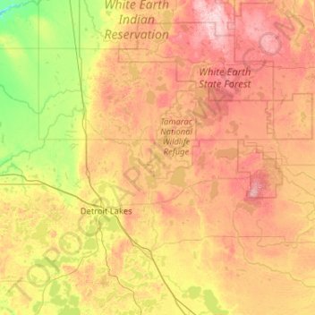
Nombre: Mapa topográfico Becker County, altitud, relieve.
Lugar: Becker County, Minnesota, United States (46.71753 -96.19484 47.15256 -95.16219)
Altitud media: 439 m
Altitud mínima: 324 m
Altitud máxima: 597 m
Otros mapas topográficos
Haga clic en un mapa para ver su topografía, su altitud y su relieve.
Countryside Mobile Home Park
United States > Minnesota > Pennington County > Thief River Falls
Altitud media: 344 m
Mississippi River
United States > Minnesota > Hennepin County > Minneapolis
The uppermost lock and dam on the Upper Mississippi River is the Upper St. Anthony Falls Lock and Dam in Minneapolis. Above the dam, the river's elevation is 799 feet (244 m). Below the dam, the river's elevation is 750 feet (230 m). This 49-foot (15 m) drop is the largest of all the Mississippi River locks…
Altitud media: 256 m
Ancient River Warren Channel (historical)
United States > Minnesota > Traverse County
Altitud media: 300 m
Sungold Heights Mobile Home Park
United States > Minnesota > Nobles County > Worthington
Altitud media: 482 m
Natalie Webb Familly Aquatic Center
United States > Minnesota > Dodge County > Dodge Center > Valley View Park
Altitud media: 384 m
Eagle Mountain
United States > Minnesota > Cook County
Eagle Mountain is only about 15 miles (24 km) from Minnesota's lowest elevation, Lake Superior, at 600 feet (183 m). It is part of the Canadian Shield. Confusingly, there is another much shorter peak also named Eagle Mountain in northern Minnesota. The shorter peak is part of the Lutsen Mountains ski resort.
Altitud media: 596 m
Eden Prairie
United States > Minnesota > Hennepin County > Eden Prairie > Eden Prairie
Altitud media: 267 m