
Mapa topográfico Snaefell
Mapa interactivo
Haga clic en el mapa para ver la altitud.
Acerca de este mapa
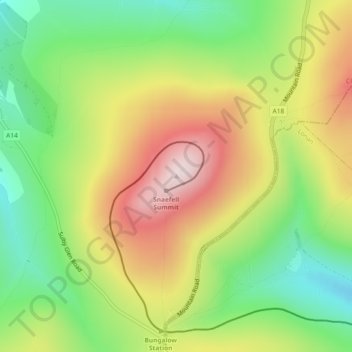
Nombre: Mapa topográfico Snaefell, altitud, relieve.
Lugar: Snaefell, Lezayre, Ayre, Isle of Man (54.26319 -4.46172 54.26329 -4.46162)
Altitud media: 391 m
Altitud mínima: 202 m
Altitud máxima: 619 m
Otros mapas topográficos
Haga clic en un mapa para ver su topografía, su altitud y su relieve.
Yellow Stone
Isle of Man > Ayre > Lezayre
Yellow Stone, Lezayre, Ayre, IM4 7NY, Isle of Man
Altitud media: 407 m