
Mapa topográfico Batangas City
Mapa interactivo
Haga clic en el mapa para ver la altitud.
Batangas City
The city is the center of the radio listening market in Batangas, and is served by local radio stations, as well as some radio stations from Lipa and other parts of the Mega Manila area. The Roman Catholic Archdiocese of Lipa, through the Radyo Bayanihan System, hosts two local radio stations: ALFM 95.9 Radyo Totoo (DWAL), a religion, news, talk, and music-oriented station, and 99.1 Spirit FM (DWAM), a religion and music-oriented station. Other radio stations include 91.9 Air1 Radio Southern Tagalog (DWCH), an adult contemporary-oriented station, 99.9 GV FM (DZGV), a contemporary hit radio station, and 104.7 Brigada News FM (DWEY), a FM news radio station. Batangas State University hosts a college radio station, 107.3 BatStateU FM (DWPB-FM). Signals from other stations in Metro Manila are not clearly received because of the local topography.
Acerca de este mapa
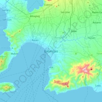
Nombre: Mapa topográfico Batangas City, altitud, relieve.
Lugar: Batangas City, Batangas, Calabarzon, 4200, Philippines (13.59612 120.89775 13.91612 121.21775)
Altitud media: 108 m
Altitud mínima: -2 m
Altitud máxima: 944 m
Otros mapas topográficos
Haga clic en un mapa para ver su topografía, su altitud y su relieve.