
Mapa topográfico Vadnais Heights
Mapa interactivo
Haga clic en el mapa para ver la altitud.
Acerca de este mapa
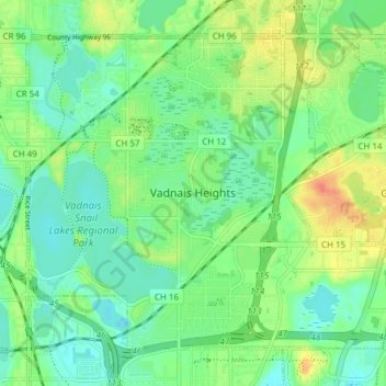
Nombre: Mapa topográfico Vadnais Heights, altitud, relieve.
Altitud media: 279 m
Altitud mínima: 263 m
Altitud máxima: 309 m
Otros mapas topográficos
Haga clic en un mapa para ver su topografía, su altitud y su relieve.
Saint Paul
United States > Minnesota > Ramsey County > Saint Paul
The year 1858 saw more than 1,000 steamboats service Saint Paul, making it a gateway for settlers to the Minnesota frontier or Dakota Territory. Geography was a primary reason the city became a transportation hub. The location was the last good point to land riverboats coming upriver due to the river valley's…
Altitud media: 273 m