
Mapa topográfico City of Lockport
Mapa interactivo
Haga clic en el mapa para ver la altitud.
Acerca de este mapa
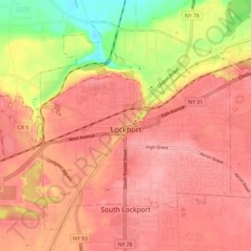
Nombre: Mapa topográfico City of Lockport, altitud, relieve.
Altitud media: 174 m
Altitud mínima: 106 m
Altitud máxima: 203 m
Lockport is at the junction of several major truck routes, including NY Route 78 (Transit Road), NY Route 31, NY Route 77 and NY Route 93. It is 17 miles north of Interstate 90 via NY Route 78. The highest point is the bell tower at 452 High Street, with the street itself being the highest street as measured by frontage above the 650 feet elevation.
Otros mapas topográficos
Haga clic en un mapa para ver su topografía, su altitud y su relieve.
Lockport
United States > New York > Niagara County
Lockport, City of Lockport, Niagara County, New York, 14094, United States
Altitud media: 152 m
City of North Tonawanda
United States > New York > Niagara County > City of North Tonawanda
City of North Tonawanda, Niagara County, New York, 14120, United States
Altitud media: 177 m
Niagara Falls
United States > New York > Niagara County > Niagara Falls
Niagara Falls, Niagara County, New York, 14302, United States
Altitud media: 158 m
City of Niagara Falls
United States > New York > Niagara County
City of Niagara Falls, Niagara County, New York, United States
Altitud media: 180 m
Burt
United States > New York > Niagara County > Burt
Burt, Newfane, Niagara County, New York, 14028, United States
Altitud media: 96 m