
Haz una donación
Mapa topográfico Tolland
Haga clic en el mapa para ver la altitud.
Haz una donación
Tolland
Tolland's climate is classified as warm summer continental (Dfb), as is typical of the eastern hills of Connecticut. The area enjoys some characteristics hot-summer continental climate (Dfa) due to a relatively high July mean temperature of 70.7 °F (21.5 °C), which is very close to the threshold of 71.6 °F (22 °C) mean temperature required for a hot-summer climate. The area experiences four distinct seasons, with cold, snowy winters and warm to hot summers. The climate of Tolland is distinguished from the warmer climate of nearby Hartford, CT, due to its elevation. The area is prone to blizzards and ice storms in the winter, and during the summer it occasionally experiences tropical activity (though less severe than in lower elevations of the state). Precipitation is distributed fairly evenly throughout the year, with the wettest month being November and the driest being February.
Haz una donación
Acerca de este mapa
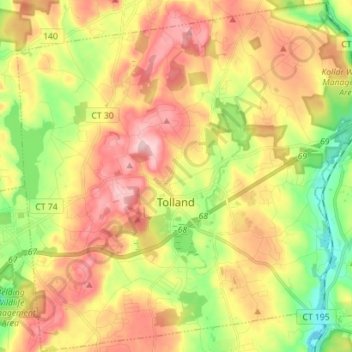
Nombre: Mapa topográfico Tolland, altitud, relieve.
Altitud media: 201 m
Altitud mínima: 94 m
Altitud máxima: 308 m
Haz una donación
Otros mapas topográficos
Haga clic en un mapa para ver su topografía, su altitud y su relieve.
Griswoldville
United States > Connecticut > Capitol Planning Region > Wethersfield
Altitud media: 34 m
Haz una donación
Johnson Hill
United States > Connecticut > Capitol Planning Region > West Hartford
Altitud media: 34 m
Haz una donación
Talcott Mountain
United States > Connecticut > Capitol Planning Region > Bloomfield
Altitud media: 152 m
Haz una donación
Stafford Springs
United States > Connecticut > Capitol Planning Region > Stafford
Altitud media: 200 m
Haz una donación
Barbara Drive
United States > Connecticut > Capitol Planning Region > Windsor Locks
Altitud media: 39 m
Whitings Corner
United States > Connecticut > Capitol Planning Region > West Hartford
Altitud media: 84 m
Haz una donación