
Mapa topográfico Camas County
Mapa interactivo
Haga clic en el mapa para ver la altitud.
Acerca de este mapa
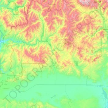
Nombre: Mapa topográfico Camas County, altitud, relieve.
Lugar: Camas County, Idaho, United States of America (43.19842 -115.08668 43.85861 -114.37772)
Altitud media: 2.002 m
Altitud mínima: 1.375 m
Altitud máxima: 3.406 m
U.S. Highway 20 runs east–west through the county's center, at elevations just over 5,000 feet (1,520 m) above sea level, connecting west to Mountain Home in Elmore County; to the east it intersects State Highway 75 in Blaine County. The northern terminus of State Highway 46 is at US-20, four miles (6.4 km) east of Fairfield; it runs south over the Mount Bennett Hills into Gooding County and on to Gooding.
Otros mapas topográficos
Haga clic en un mapa para ver su topografía, su altitud y su relieve.
Snake River
United States of America > Idaho
Snake River, Washington County, Idaho, 83672, United States of America
Altitud media: 644 m
Sawtooth National Forest
United States of America > Idaho > Rupert
Sawtooth National Forest, Sharon Court, Rupert, Minidoka County, Idaho, 83350, United States of America
Altitud media: 1.608 m
Genesee
United States of America > Idaho > Genesee
Genesee, Latah County, Idaho, 83832, United States of America
Altitud media: 824 m
Butte County
United States of America > Idaho
Butte County, Idaho, United States of America
Altitud media: 1.914 m
Chinese Peak
United States of America > Idaho
Chinese Peak, Bannock County, Idaho, United States of America
Altitud media: 1.830 m
Eagle Rock
United States of America > Idaho
Eagle Rock, Idaho County, Idaho, United States of America
Altitud media: 1.164 m
Teton
United States of America > Idaho > Teton
Teton, Fremont County, Idaho, 83451, United States of America
Altitud media: 1.509 m
Springston
United States of America > Idaho
Springston, Kootenai County, Idaho, 83833, United States of America
Altitud media: 721 m