Geolocalizar

Mapa topográfico Pegram

Mapa interactivo

Haga clic en el mapa para ver la altitud.

Acerca de este mapa

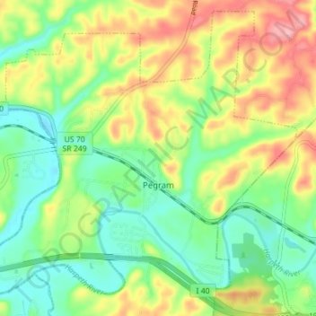
Nombre: Mapa topográfico Pegram, altitud, relieve.

Lugar: Pegram, Cheatham County, Tennessee, 37143, United States (36.07890 -87.09039 36.13173 -87.02041)

Altitud media: 195 m

Altitud mínima: 144 m

Altitud máxima: 272 m

Otros mapas topográficos

Haga clic en un mapa para ver su topografía, su altitud y su relieve.

Germantown

United States > Tennessee > Cheatham County

Germantown, Cheatham County, Middle Tennessee, Tennessee, United States

Altitud media: 199 m

Cheatham Dam

United States > Tennessee > Cheatham County

Cheatham Dam, Cheatham County, Middle Tennessee, Tennessee, United States

Altitud media: 135 m

Ashland City

United States > Tennessee > Cheatham County

Ashland City, Cheatham County, Tennessee, 37015, United States

Altitud media: 166 m

Kingston Springs

United States > Tennessee > Cheatham County

Kingston Springs, Cheatham County, Middle Tennessee, Tennessee, 37082, United States

Altitud media: 186 m

Cheatham State Wildlife Management Area

United States > Tennessee > Cheatham County

Cheatham State Wildlife Management Area, Cheatham County, Tennessee, United States

Altitud media: 205 m