
Mapa topográfico Blue Ridge Parkway
Mapa interactivo
Haga clic en el mapa para ver la altitud.
Blue Ridge Parkway
The parkway has been the most visited unit of the National Park System every year since 1946 except four (1949, 2013, 2016 and 2019).[4][5] Land on either side of the road is owned and maintained by the National Park Service, and in many places parkway land is bordered by United States Forest Service property. There is no fee for using the parkway; however, commercial vehicles are prohibited without approval from the Park Service Headquarters, near Asheville, North Carolina.[6][7] The roadway is not maintained in the winter, and sections that pass over especially high elevations and through tunnels are often impassable and therefore closed from late fall through early spring. Weather is extremely variable in the mountains, so conditions and closures often change rapidly. The speed limit is never higher than 45 mph (72 km/h) and is lower in some sections.
Acerca de este mapa
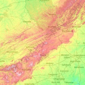
Nombre: Mapa topográfico Blue Ridge Parkway, altitud, relieve.
Altitud media: 504 m
Altitud mínima: 38 m
Altitud máxima: 1.983 m
Otros mapas topográficos
Haga clic en un mapa para ver su topografía, su altitud y su relieve.
Rich Mountain
United States > North Carolina > Watauga County
Rich Mountain is a mountain located in the North Carolina High Country, roughly 3 miles (4.8 km) northwest of the town of Boone. Its elevation reaches 4,748 feet (1,447 m).
Altitud media: 1.214 m
Boone
United States > North Carolina > Watauga County > Boone > Boone
Boone is located at 36°12′41″N 81°40′7″W / 36.21139°N 81.66861°W / 36.21139; -81.66861 (36.211364, −81.668657) and has an elevation of 3,333 feet (1015.9 m) above sea level. An earlier survey gave the elevation as 3,332 ft and since then it has been published as having an elevation of…
Altitud media: 977 m
Valle Crucis
United States > North Carolina > Watauga County
Valle Crucis is located at the banks of Dutch Creek and Watauga River, at an elevation of 2,677 feet (816 m) above sea level. To its north and east is Tester Mountain and to its south and west is Valle Mountain. The community is also within the Pisgah National Forest boundary, which limits some development in…
Altitud media: 904 m
Sorrento Skies
United States > North Carolina > Watauga County > Sorrento Skies
Altitud media: 1.069 m
Beech Mountain
United States > North Carolina > Watauga County > Beech Mountain
Altitud media: 1.264 m