
Haz una donación
Mapa topográfico Flat Rock
Haga clic en el mapa para ver la altitud.
Haz una donación
Acerca de este mapa
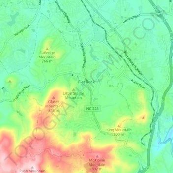
Nombre: Mapa topográfico Flat Rock, altitud, relieve.
Lugar: Flat Rock, Henderson County, North Carolina, United States (35.24084 -82.50104 35.29774 -82.41956)
Altitud media: 702 m
Altitud mínima: 589 m
Altitud máxima: 945 m
Haz una donación
Otros mapas topográficos
Haga clic en un mapa para ver su topografía, su altitud y su relieve.
Haz una donación
Haz una donación
Haz una donación
Chanteloupe Country Estates
United States > North Carolina > Henderson County > Flat Rock
Altitud media: 660 m
Haz una donación
Edneyville
United States > North Carolina > Henderson County
Edneyville is in northeastern Henderson County at an elevation of 2,246 feet (685 m) above sea level. The Eastern Continental Divide runs through the center of the CDP; the eastern side of the community drains via Reedypatch Creek to the Broad River, which flows through the Congaree and Santee River systems to…
Altitud media: 689 m
Haz una donación
Mills River
United States > North Carolina > Henderson County > Mills River > Oak Hill Court
Altitud media: 633 m
Claremont
United States > North Carolina > Henderson County > Flat Rock > Claremont
Altitud media: 713 m
Haz una donación
Mills River
United States > North Carolina > Henderson County > Mills River > Oak Hill Court
Altitud media: 644 m
Flat Rock Forest
United States > North Carolina > Henderson County > Flat Rock > Flat Rock Forest
Altitud media: 681 m