
Mapa topográfico Tête de Ferret
Mapa interactivo
Haga clic en el mapa para ver la altitud.
Acerca de este mapa
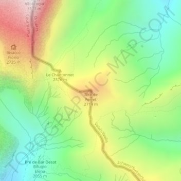
Nombre: Mapa topográfico Tête de Ferret, altitud, relieve.
Lugar: Tête de Ferret, Courmayeur, Valle d'Aosta, Italia (45.89510 7.07647 45.89520 7.07657)
Altitud media: 2.366 m
Altitud mínima: 1.865 m
Altitud máxima: 3.108 m
Otros mapas topográficos
Haga clic en un mapa para ver su topografía, su altitud y su relieve.
Larzey
Italia > Valle d'Aosta > Courmayeur > Larzey
Larzey, Courmayeur, Valle d'Aosta, 11013, Italia
Altitud media: 1.596 m
Rifugio Torino nuovo
Italia > Valle d'Aosta > Courmayeur
Rifugio Torino nuovo, Sentiero Pavillon rifugio Torino, Courmayeur, Valle d'Aosta, Italia
Altitud media: 3.025 m
Ghiacciaio del Miage
Italia > Valle d'Aosta > Courmayeur
Ghiacciaio del Miage, Sentiero 15 Rifugio Gonella, Courmayeur, Valle d'Aosta, Italia
Altitud media: 2.911 m