
Mapa topográfico Salisbury
Mapa interactivo
Haga clic en el mapa para ver la altitud.
Acerca de este mapa
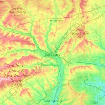
Nombre: Mapa topográfico Salisbury, altitud, relieve.
Altitud media: 96 m
Altitud mínima: 13 m
Altitud máxima: 241 m
Bishop of Salisbury Hubert Walter was instrumental in the negotiations with Saladin during the Third Crusade, but he spent little time in his diocese prior to his elevation to archbishop of Canterbury. The brothers Herbert and Richard Poore succeeded him and began planning the relocation of the cathedral into the valley almost immediately. Their plans were approved by King Richard I but repeatedly delayed: Herbert was first forced into exile in Normandy in the 1190s by the hostility of his archbishop Walter and then again to Scotland in the 1210s owing to royal hostility following the papal interdiction against King John. The secular authorities were particularly incensed, according to tradition, owing to some of the clerics debauching the castellan's female relations. In the end, the clerics were refused permission to reenter the city walls following their rogations and processions. This caused Peter of Blois to describe the church as "a captive within the walls of the citadel like the ark of God in the profane house of Baal". He advocated
Otros mapas topográficos
Haga clic en un mapa para ver su topografía, su altitud y su relieve.
Marlborough
United Kingdom > England > Salisbury > Marlborough
Marlborough, Wiltshire, South West England, England, SN8, United Kingdom
Altitud media: 175 m
River Ebble
United Kingdom > England > Salisbury
River Ebble, Salisbury, Wiltshire, South West England, England, SP5 4JB, United Kingdom
Altitud media: 69 m
River Nadder
United Kingdom > England > Salisbury
River Nadder, Salisbury, Wiltshire, South West England, England, SP2 7RZ, United Kingdom
Altitud media: 59 m