
Mapa topográfico Bonners Ferry
Mapa interactivo
Haga clic en el mapa para ver la altitud.
Acerca de este mapa
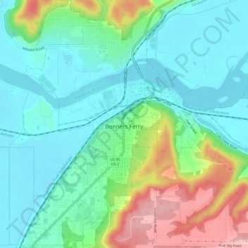
Nombre: Mapa topográfico Bonners Ferry, altitud, relieve.
Altitud media: 584 m
Altitud mínima: 531 m
Altitud máxima: 716 m
Bonners Ferry is located 27 miles (43.5 km) south of the Canada-United States border at 48°41′32″N 116°19′3″W / 48.69222°N 116.31750°W / 48.69222; -116.31750 (48.692110, −116.317626), at an altitude of 1,896 feet (578 m). According to the United States Census Bureau, the city has a total area of 2.61 square miles (6.76 km2), of which 2.44 square miles (6.32 km2) is land and 0.17 square miles (0.44 km2) is water.
Otros mapas topográficos
Haga clic en un mapa para ver su topografía, su altitud y su relieve.
Canida Peak
United States > Idaho > Boundary County
Canida Peak, Boundary County, Idaho, United States
Altitud media: 1.345 m