
Mapa topográfico City of Chester
Mapa interactivo
Haga clic en el mapa para ver la altitud.
Acerca de este mapa
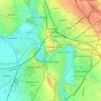
Nombre: Mapa topográfico City of Chester, altitud, relieve.
Altitud media: 21 m
Altitud mínima: 2 m
Altitud máxima: 48 m
Otros mapas topográficos
Haga clic en un mapa para ver su topografía, su altitud y su relieve.
Neston
United Kingdom > England > Chester
Neston, Chester, Cheshire West and Chester, North West England, England, CH64 9UY, United Kingdom
Altitud media: 32 m
Liverpool Bay
United Kingdom > England > Chester
Liverpool Bay, Chester, Cheshire West and Chester, North West England, England, United Kingdom
Altitud media: 0 m
Wych Brook
United Kingdom > England > Chester
Wych Brook, Chester, Cheshire West and Chester, North West England, England, SY14 7NG, United Kingdom
Altitud media: 72 m