
Mapa topográfico Tryon
Mapa interactivo
Haga clic en el mapa para ver la altitud.
Acerca de este mapa
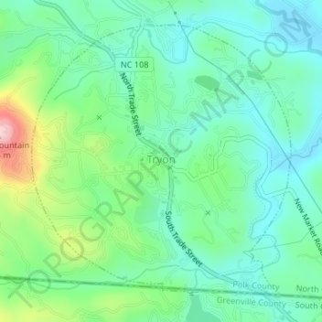
Nombre: Mapa topográfico Tryon, altitud, relieve.
Lugar: Tryon, Polk County, North Carolina, United States (35.19654 -82.25175 35.21942 -82.22512)
Altitud media: 333 m
Altitud mínima: 272 m
Altitud máxima: 498 m
The elevation of the town is 1,067 feet (325 m) above sea level. The town's original boundary was established as a circle with a radius of three quarters of a mile. According to the United States Census Bureau, the town has a total area of 1.8 square miles (4.7 km2), all land.
Otros mapas topográficos
Haga clic en un mapa para ver su topografía, su altitud y su relieve.
Peniel
United States > North Carolina > Polk County
Peniel, Polk County, North Carolina, 28722, United States
Altitud media: 326 m
Saluda
United States > North Carolina > Polk County
Saluda, Polk County, North Carolina, 28773, United States
Altitud media: 635 m
Howard Gap
United States > North Carolina > Polk County
Howard Gap, Polk County, North Carolina, United States
Altitud media: 573 m