
Haz una donación
Mapa topográfico Campbell County
Haga clic en el mapa para ver la altitud.
Haz una donación
Campbell County
Campbell County is situated in a geological border region between the Cumberland Mountains in the northwest and the Appalachian Ridge-and-Valley Range in the southeast. This border area is characterized by several large, elongated ridges, namely Cross Mountain in the west and Cumberland Mountain, Walnut Mountain, and Pine Mountain to the north. Ivydale, situated in the Cumberland Mountains region, is the exact geographical center of Campbell County. Elevations vary widely across the county, ranging from 3,534 ft (1,077 m) at Cross Mountain to slightly less than 1,000 ft (300 m) a few miles away at Norris Lake. Norris Lake— an artificial reservoir created by the Tennessee Valley Authority in the 1930s— is the main body of water in the region. It is fed by the Clinch and Powell Rivers, as well as several large creeks, most notably Davis Creek, Big Creek, and Cove Creek. Cove Creek also feeds the much smaller Cove Lake— a recreational lake built by TVA in the 1930s as part of the Norris project— which is located near Caryville.
Haz una donación
Acerca de este mapa
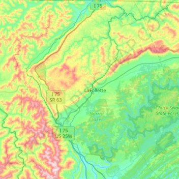
Nombre: Mapa topográfico Campbell County, altitud, relieve.
Lugar: Campbell County, East Tennessee, Tennessee, United States (36.17758 -84.37663 36.59218 -83.89953)
Altitud media: 473 m
Altitud mínima: 249 m
Altitud máxima: 1.071 m
Haz una donación
Otros mapas topográficos
Haga clic en un mapa para ver su topografía, su altitud y su relieve.
Haz una donación
Haz una donación
Sugarlands
United States > Tennessee > Sevier County
In the 19the century, mountain areas became popular vacation destinations, especially since large urban areas were often wanting for clean air and scenery. Mineral-rich mountain springs were thought to have health-restoring qualities, and the cool air of the higher elevations lured people seeking relief from…
Altitud media: 607 m
Haz una donación
Haz una donación
Haz una donación
Mount Le Conte
United States > Tennessee > Sevier County
Mount Le Conte (or LeConte) is a mountain located within the Great Smoky Mountains National Park in Sevier County, Tennessee. At 6,593 ft (2,010 m) it is the third highest peak in the national park, behind Kuwohi (formerly Clingmans Dome) (6,643 ft (2,025 m)) and Mount Guyot (6,621 ft (2,018 m)). It is also…
Altitud media: 1.661 m
Haz una donación
Haz una donación
Haz una donación
Haz una donación
Haz una donación
Haz una donación
House Mountain
United States > Tennessee > Knox County
House Mountain is a mountain located in Corryton, Tennessee, United States, about 8 miles (13 km) northeast of Knoxville. Rising to an elevation of 2,064 feet (629 m) above sea level, House Mountain is the highest point in Knox County.
Altitud media: 394 m
Haz una donación
Haz una donación
Haz una donación
Harpeth River Greenway
United States > Tennessee > Davidson County > Nashville > Harpeth River Estates
Altitud media: 182 m
Haz una donación
Haz una donación
Haz una donación
Haz una donación
Haz una donación
Haz una donación
Haz una donación
Haz una donación
Haz una donación
Haz una donación
Haz una donación