
Mapa topográfico Campbell County
Mapa interactivo
Haga clic en el mapa para ver la altitud.
Campbell County
Campbell County is situated in a geological border region between the Cumberland Mountains in the northwest and the Appalachian Ridge-and-Valley Range in the southeast. This border area is characterized by several large, elongated ridges, namely Cross Mountain in the west and Cumberland Mountain, Walnut Mountain, and Pine Mountain to the north. Ivydale, situated in the Cumberland Mountains region, is the exact geographical center of Campbell County. Elevations vary widely across the county, ranging from 3,534 ft (1,077 m) at Cross Mountain to slightly less than 1,000 ft (300 m) a few miles away at Norris Lake. Norris Lake— an artificial reservoir created by the Tennessee Valley Authority in the 1930s— is the main body of water in the region. It is fed by the Clinch and Powell Rivers, as well as several large creeks, most notably Davis Creek, Big Creek, and Cove Creek. Cove Creek also feeds the much smaller Cove Lake— a recreational lake built by TVA in the 1930s as part of the Norris project— which is located near Caryville.
Acerca de este mapa
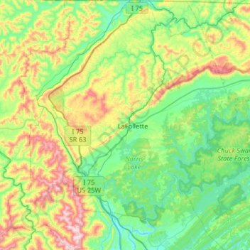
Nombre: Mapa topográfico Campbell County, altitud, relieve.
Lugar: Campbell County, East Tennessee, Tennessee, United States (36.17758 -84.37663 36.59218 -83.89953)
Altitud media: 473 m
Altitud mínima: 249 m
Altitud máxima: 1.071 m
Otros mapas topográficos
Haga clic en un mapa para ver su topografía, su altitud y su relieve.
Pinson Mounds State Archaeological Area
United States > Tennessee > Madison County
Altitud media: 120 m
Millersville City Park
United States > Tennessee > Robertson County > Millersville
Altitud media: 260 m
Edwin Warner Park
United States > Tennessee > Davidson County > Nashville > Devonshire Manor
Altitud media: 198 m
Douglas Dam
United States > Tennessee > Sevier County > Sevierville
The Douglas Project required the construction of ten smaller, earthen saddle dams to fill in gaps along the adjacent ridgeline and permit a higher water elevation than would otherwise be possible. Most of these saddle dams are located in the hills southeast of the main dam. One protects downtown Dandridge,…
Altitud media: 312 m
Barfield Crescent Park
United States > Tennessee > Rutherford County > Murfreesboro
Altitud media: 201 m