
Mapa topográfico Tirunelveli
Mapa interactivo
Haga clic en el mapa para ver la altitud.
Acerca de este mapa
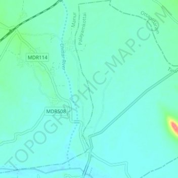
Nombre: Mapa topográfico Tirunelveli, altitud, relieve.
Altitud media: 34 m
Altitud mínima: 24 m
Altitud máxima: 91 m
Tirunelveli is located at 8°43′41.82″N 77°41′43.94″E / 8.7282833°N 77.6955389°E / 8.7282833; 77.6955389, and its average elevation is 47 metres (154 ft). It is located at the southernmost tip of the Deccan plateau. The Tamirabarani River divides the city into the Tirunelveli quarter and the Palayamkottai area. The river (with its tributaries, such as the Chittar) is the major source of irrigation, and is fed by the northeast and southwest monsoons. The major lakes in the city are Nainar Lake and Udayarpetti Lake. The area around the Tamirabarani River and the Chittar has five streams: Kodagan, Palayan, Tirunelveli, Marudur East and Marudur West, and the Chittar feeds fifteen other channels. The soil is friable, red and sandy.
Otros mapas topográficos
Haga clic en un mapa para ver su topografía, su altitud y su relieve.
Thamirabharani
India > Tamil Nadu > Tirunelveli
Thamirabharani, Tirunelveli, Tirunelveli District, Tamil Nadu, 627001, India
Altitud media: 35 m
Tirunelveli
India > Tamil Nadu > Tirunelveli
Tirunelveli, Tirunelveli Kattabo, Tamil Nadu, India
Altitud media: 65 m