
Haz una donación
Mapa topográfico Apollo Beach
Haga clic en el mapa para ver la altitud.
Haz una donación
Apollo Beach
The history of Apollo Beach started in 1923 on land owned by the Dickman family, then used annually for farming and grazing pasture. Much of the land was mangrove and low-elevation and was considered uninhabitable.
Haz una donación
Acerca de este mapa
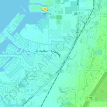
Nombre: Mapa topográfico Apollo Beach, altitud, relieve.
Altitud media: 6 m
Altitud mínima: -3 m
Altitud máxima: 35 m
Haz una donación
Otros mapas topográficos
Haga clic en un mapa para ver su topografía, su altitud y su relieve.
Kings Point Heritage Park
United States > Florida > Hillsborough County > Sun City Center
Altitud media: 16 m
Haz una donación
Carrollwood
United States > Florida > Hillsborough County
Carrollwood is located at 28.1 degrees north, 82.5 degrees west (28.0523, -82.4858). The elevation for the community is 39 feet (12 m) above sea level.
Altitud media: 16 m
Haz una donación
Haz una donación
Haz una donación
The Borghese Villas at Westshore
United States > Florida > Hillsborough County > Tampa
Altitud media: 9 m
Lutz
United States > Florida > Hillsborough County > Tampa
Lutz is characterized by a gently rolling topography that showcases the distinctive features of the central Florida landscape. The area has an average elevation of about 70 feet (21 meters) above sea level, contributing to its mild undulations rather than dramatic elevation changes. The terrain is marked by a…
Altitud media: 20 m
Haz una donación
Keystone Park
United States > Florida > Hillsborough County > Keystone > Keystone Terrace
Altitud media: 17 m
Keystone Park
United States > Florida > Hillsborough County > Keystone > Keystone Terrace
Altitud media: 17 m
Haz una donación
Haz una donación
Haz una donación
Haz una donación
Arbors at Freedom Plaza
United States > Florida > Hillsborough County > Sun City Center
Altitud media: 15 m
Club Manor East of Grand Hampton
United States > Florida > Hillsborough County > Tampa
Altitud media: 17 m
Haz una donación
Haz una donación
Haz una donación
The Borghese Villas at Westshore
United States > Florida > Hillsborough County > Tampa
Altitud media: 9 m
Haz una donación
Carrollwood
United States > Florida > Hillsborough County > Tampa
Carrollwood is located at 28.1 degrees north, 82.5 degrees west (28.0523, -82.4858). The elevation for the community is 39 feet (12 m) above sea level.
Altitud media: 16 m
Haz una donación
Haz una donación
Haz una donación
Haz una donación
Haz una donación
Haz una donación
Haz una donación
Haz una donación
Carrollwood
United States > Florida > Hillsborough County > Tampa
Carrollwood is located at 28.1 degrees north, 82.5 degrees west (28.0523, -82.4858). The elevation for the community is 39 feet (12 m) above sea level.
Altitud media: 16 m
Haz una donación
Haz una donación
Haz una donación
Egypt Lake-Leto
United States > Florida > Hillsborough County
Egypt Lake-Leto is located in northwestern Hillsborough County at 28°0′55″N 82°30′26″W / 28.01528°N 82.50722°W / 28.01528; -82.50722 (28.015396, -82.507311), 7 miles (11 km) northwest of downtown Tampa. The elevation for the CDP is 45 feet (14 m) above sea level.
Altitud media: 15 m
Haz una donación