
Mapa topográfico Lewiston
Mapa interactivo
Haga clic en el mapa para ver la altitud.
Acerca de este mapa
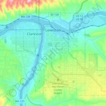
Nombre: Mapa topográfico Lewiston, altitud, relieve.
Lugar: Lewiston, Nez Perce County, Idaho, 83501, United States (46.36165 -117.04659 46.43711 -116.91126)
Altitud media: 334 m
Altitud mínima: 219 m
Altitud máxima: 758 m
According to the U.S. Census Bureau, the city has a total area of 18.04 square miles (46.72 km2), of which 17.23 square miles (44.63 km2) is land and 0.81 square miles (2.10 km2) is water. Downtown Lewiston, at elevations between 740 feet (230 m) and 780 feet (240 m), is only slightly higher in elevation than the river, about 741 ft (226 m), which was thirty feet (9 m) lower prior to the completion of the Lower Granite Dam. Away from downtown the terrain gains elevation quickly, as the steep riverbank highway of U.S. 95 north of Lewiston ascends to 2,756 feet (840 m).
Otros mapas topográficos
Haga clic en un mapa para ver su topografía, su altitud y su relieve.
Culdesac
United States > Idaho > Nez Perce County
Culdesac, Nez Perce County, Idaho, United States
Altitud media: 588 m