
Mapa topográfico Rocky Mountain National Park
Mapa interactivo
Haga clic en el mapa para ver la altitud.
Rocky Mountain National Park
Rocky Mountain National Park is one of the highest national parks in the nation, with elevations from 7,860 to 14,259 feet (2,396 to 4,346 m), the highest point of which is Longs Peak. Trail Ridge Road is the highest paved through-road in the country, with a peak elevation of 12,183 feet (3,713 m). Sixty mountain peaks over 12,000 feet (3,658 m) high provide scenic vistas. On the north side of the park, the Mummy Range contains a number of thirteener peaks, including Hagues Peak, Mummy Mountain, Fairchild Mountain, Ypsilon Mountain, and Mount Chiquita. Several small glaciers and permanent snowfields are found in the high mountain cirques.
Acerca de este mapa
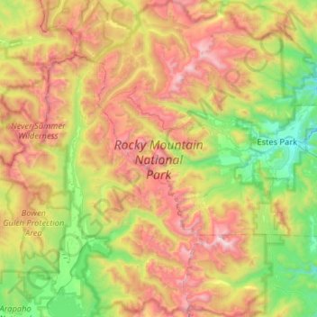
Nombre: Mapa topográfico Rocky Mountain National Park, altitud, relieve.
Altitud media: 3.073 m
Altitud mínima: 2.248 m
Altitud máxima: 4.340 m
Otros mapas topográficos
Haga clic en un mapa para ver su topografía, su altitud y su relieve.
Estes Park
United States > Colorado > Larimer County
Estes Park sits at an elevation of 7,522 feet (2,293 m) on the front range of the Rocky Mountains at the eastern entrance of the Rocky Mountain National Park. Its north, south and east extremities border the Roosevelt National Forest. Lumpy Ridge lies immediately north of Estes Park.
Altitud media: 2.543 m
Estes Park
United States > Colorado > Larimer County
Estes Park sits at an elevation of 7,522 feet (2,293 m) on the front range of the Rocky Mountains at the eastern entrance of the Rocky Mountain National Park. Its north, south and east extremities border the Roosevelt National Forest. Lumpy Ridge lies immediately north of Estes Park.
Altitud media: 2.429 m
Estes Park
United States > Colorado > Larimer County
Estes Park sits at an elevation of 7,522 feet (2,293 m) on the front range of the Rocky Mountains at the eastern entrance of the Rocky Mountain National Park. Its north, south and east extremities border the Roosevelt National Forest. Lumpy Ridge lies immediately north of Estes Park.
Altitud media: 2.420 m
Horseshoe Lake (South Dam)
United States > Colorado > Larimer County > Loveland
Altitud media: 1.515 m
Stanley Heights Subdivision
United States > Colorado > Larimer County > Estes Park
Altitud media: 2.345 m
Estes Park
United States > Colorado > Larimer County
Estes Park sits at an elevation of 7,522 feet (2,293 m) on the front range of the Rocky Mountains at the eastern entrance of the Rocky Mountain National Park. Its location is 40°22′22″N 105°31′09″W / 40.372856°N 105.519136°W / 40.372856; -105.519136. Its north, south and east extremities…
Altitud media: 2.409 m