
Mapa topográfico Orofino
Mapa interactivo
Haga clic en el mapa para ver la altitud.
Acerca de este mapa
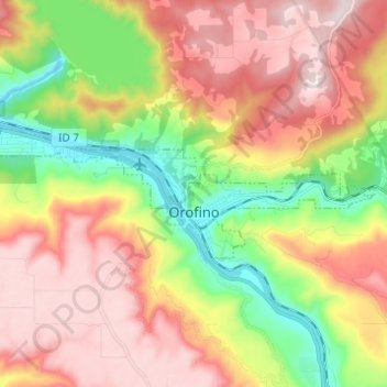
Nombre: Mapa topográfico Orofino, altitud, relieve.
Lugar: Orofino, Clearwater County, Idaho, 83544, United States (46.47097 -116.32122 46.49939 -116.19855)
Altitud media: 633 m
Altitud mínima: 293 m
Altitud máxima: 964 m
The city has a climate typical of low-elevation areas in Idaho and eastern Washington. Orofino has a dry-summer continental climate (Köppen Dsb). Due to the warm summers, it nearly qualifies as a continental Mediterranean climate (Dsa). Idaho’s all-time highest temperature of 118 °F or 47.8 °C was recorded at Orofino on July 28, 1934.
Otros mapas topográficos
Haga clic en un mapa para ver su topografía, su altitud y su relieve.
Clearwater County
United States > Idaho > Clearwater County
Clearwater County, Idaho, United States
Altitud media: 1.250 m
Platinum Lake
United States > Idaho > Clearwater County
Platinum Lake, Clearwater County, Idaho, United States
Altitud media: 1.723 m