
Mapa topográfico Ankara
Mapa interactivo
Haga clic en el mapa para ver la altitud.
Acerca de este mapa
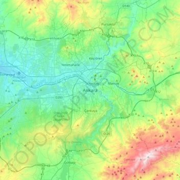
Nombre: Mapa topográfico Ankara, altitud, relieve.
Altitud media: 1.082 m
Altitud mínima: 798 m
Altitud máxima: 1.864 m
Ankara has a cold semi-arid climate (Köppen climate classification: BSk). Under the Trewartha climate classification, Ankara has a temperate humid continental climate (Dc). Due to its elevation and inland location, Ankara has cold and snowy winters, and hot and dry summers. Rainfall occurs mostly during the spring and autumn. The city lies in USDA Hardiness zone 7b, and its annual average precipitation is fairly low at 414 millimeters (16 in), nevertheless precipitation can be observed throughout the year. Monthly mean temperatures range from 0.9 °C (33.6 °F) in January to 24.3 °C (75.7 °F) in July, with an annual mean of 12.6 °C (54.7 °F).
Otros mapas topográficos
Haga clic en un mapa para ver su topografía, su altitud y su relieve.
Kocatepe Mahallesi
Kocatepe Mahallesi, Çankaya, Ankara, Central Anatolia Region, 06660, Turkey
Altitud media: 896 m
Harbiye Mahallesi
Harbiye Mahallesi, Çankaya, Ankara, Central Anatolia Region, Turkey
Altitud media: 1.004 m
Koru Mahallesi
Koru Mahallesi, Çankaya, Ankara, Central Anatolia Region, Turkey
Altitud media: 900 m
Çayyolu Mahallesi
Çayyolu Mahallesi, Çankaya, Ankara, Central Anatolia Region, Turkey
Altitud media: 921 m
Ayrancı Mahallesi
Ayrancı Mahallesi, Çankaya, Ankara, Central Anatolia Region, Turkey
Altitud media: 975 m