
Mapa topográfico Bentonville
Mapa interactivo
Haga clic en el mapa para ver la altitud.
Acerca de este mapa
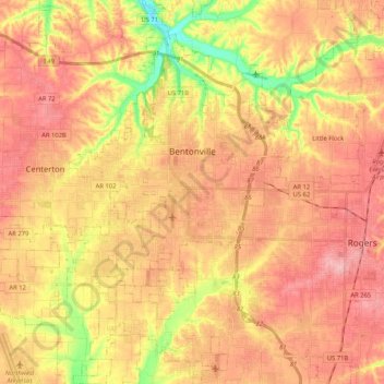
Nombre: Mapa topográfico Bentonville, altitud, relieve.
Lugar: Bentonville, Benton County, Arkansas, United States (36.27106 -94.32624 36.43871 -94.15459)
Altitud media: 387 m
Altitud mínima: 309 m
Altitud máxima: 436 m
Bentonville lies in the humid subtropical climate zone (Köppen Cfa) with influence from the humid continental climate type. Bentonville experiences all four seasons and does receive cold air masses from the north, however some of the Arctic masses are blocked by the higher elevations of the Ozarks. July is the hottest month of the year, with an average high of 89 °F (32 °C) and an average low of 66 °F (19 °C). Temperatures above 100 °F (37.8 °C) are common, with recent temperatures during summer months staying above 100 degrees for several weeks at a time. January is the coldest month with an average high of 46 °F (8 °C) and an average low of 24 °F (−4 °C). The city's highest temperature was 114 °F (45.6 °C), recorded in 1954. The lowest temperature recorded was −16 °F (−26.7 °C), in 1996.
Otros mapas topográficos
Haga clic en un mapa para ver su topografía, su altitud y su relieve.
Lowell
United States > Arkansas > Benton County
Lowell, Benton County, Arkansas, United States
Altitud media: 404 m
Maysville
United States > Arkansas > Benton County
Maysville, Benton County, Arkansas, 72747, United States
Altitud media: 323 m
Gravette
United States > Arkansas > Benton County
Gravette, Benton County, Arkansas, United States
Altitud media: 356 m
Prairie Creek
United States > Arkansas > Benton County > Rogers
Prairie Creek, Rogers, Benton County, Arkansas, United States
Altitud media: 389 m
Garfield
United States > Arkansas > Benton County
Garfield, Benton County, Arkansas, 72732, United States
Altitud media: 453 m
Hiwasse
United States > Arkansas > Benton County > Gravette
Hiwasse, Gravette, Benton County, Arkansas, 72739, United States
Altitud media: 394 m
Siloam Springs
United States > Arkansas > Benton County
Siloam Springs, Benton County, Arkansas, 72761, United States
Altitud media: 339 m
Blowing Springs Bike & Fitness Park
United States > Arkansas > Benton County > Bella Vista
Blowing Springs Bike & Fitness Park, Bella Vista, Benton County, Arkansas, 72715, United States
Altitud media: 351 m
Centerton
United States > Arkansas > Benton County
Centerton, Benton County, Arkansas, 72719, United States
Altitud media: 393 m
Norwood
United States > Arkansas > Benton County
Norwood, Benton County, Arkansas, United States
Altitud media: 347 m
Bella Vista
United States > Arkansas > Benton County
Bella Vista, Benton County, Arkansas, 72715, United States
Altitud media: 372 m
Bentonville
United States > Arkansas > Benton County > Bentonville > Bentonville
Bentonville, Benton County, Arkansas, 72712, United States
Altitud media: 383 m
Rago
United States > Arkansas > Benton County > Bella Vista > Rago
Rago, Bella Vista, Benton County, Arkansas, 72715, United States
Altitud media: 378 m
Rogers
United States > Arkansas > Benton County
Rogers, Benton County, Arkansas, United States
Altitud media: 393 m