
Haz una donación
Mapa topográfico Southern Leyte
Haga clic en el mapa para ver la altitud.
Haz una donación
Southern Leyte
Along with other mountain forms in the province, Mount Nacolod in Hinunangan town has the highest peak with an elevation of 948 metres (3,110 ft) above sea level. Young volcanic rocks are discovered in the terrain areas, which cover the top of the southern mountain ranges of Mount Cabalian in the Pacific Area and Mount Nelangcapan in Panaon Area.
Haz una donación
Acerca de este mapa
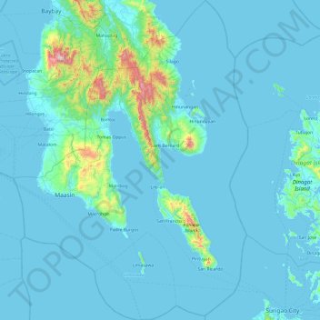
Nombre: Mapa topográfico Southern Leyte, altitud, relieve.
Lugar: Southern Leyte, Eastern Visayas, Philippines (9.76033 124.68340 10.70524 125.39128)
Altitud media: 66 m
Altitud mínima: -1 m
Altitud máxima: 1.108 m
Haz una donación
Otros mapas topográficos
Haga clic en un mapa para ver su topografía, su altitud y su relieve.
Baguio
In 1903, Filipinos, Japanese and Chinese workers were hired to build Kennon Road, the first road directly connecting Baguio with the lowlands of La Union and Pangasinan. Before this, the only road to Benguet was Naguilian Road, and it was largely a horse trail at higher elevations. Camp John Hay was…
Altitud media: 881 m
Quezon City
Founded as a pueblo by Saint Pedro Bautista in 1590, San Francisco del Monte may be considered Quezon City's oldest district. The original land area of the old town of San Francisco del Monte was approximately2.5 square kilometres (1.0 sq mi) and covered parts of what is currently known as Project 7 and 8 and…
Altitud media: 57 m
Bacolod
Bacólod (English: Bacolod), is derived from bakólod (Old Spelling: bacólod), the Old Hiligaynon (Old Ilonggo) (Old Spelling: Ylongo and Ilongo) word for a "hill, turtle, mound, rise, hillock, down, any small eminence or elevation", since the resettlement was founded on a stony, hilly area, now the barangay…
Altitud media: 49 m
Haz una donación
Zamboanga City
Philippines > Zamboanga Peninsula > Zamboanga City
The overall topography of the city could be described as rolling to very steep. There are some flat lands, mostly narrow strips along the east coast. The urban center is mostly flat with a gentle slope to the interior, ranging from 0 to 3%. The highest registered elevation is 1,200 metres. In terms of slope, a…
Altitud media: 83 m
Haz una donación
Legazpi
Legazpi's topography is generally plain on the northeastern areas, with slopes ranging from five to fifteen degrees. The southern areas have mostly rolling to hilly terrain. In the city's coastal areas, the terrain varies from plain (north) to hilly (south). Legazpi is criss-crossed by several rivers including…
Altitud media: 150 m
Haz una donación
Vigan
Vigan is situated in a Quaternary Age sedimentary plain called the Vigan-Bantay Plain which is part of the Ilocos coastal plain. The Vigan-Bantay Plain is bounded on the east by a moderately rugged Miocene sediments consisting of interbedded sandstones and shale to very rugged Meta-volcanics and Meta sediment…
Altitud media: 63 m
Haz una donación
Haz una donación
Daraga
67.3% of the total municipal land area has a predominantly low elevation of up to 100 metres (330 ft). The surface terrain is generally characterized by combination of level to nearly level areas, gentle to undulating areas and undulating to rolling areas.
Altitud media: 76 m
Haz una donación
Haz una donación
Haz una donación
Tagaytay
The southern and eastern portions of Tagaytay are covered by hills and mountains which is generally forests, pine trees and open grasslands. The city lies along Tagaytay Ridge, a ridge stretching about 32 kilometres (20 mi) from Mount Batulao in the west to Mount Sungay in the east with elevations averaging…
Altitud media: 229 m
Malolos
Malolos is relatively flat of about 0.81% to a gently sloping of 2.17%. The slope of the land descends towards west, southwest to southern direction. The highest land elevation is at about 6.0 meters above sea level while the lowest is only half a meter below sea level. A network of natural waterways and…
Altitud media: 6 m
Haz una donación
Haz una donación
Haz una donación
Haz una donación
Tagum
One of the significant accomplishments of the officialdom of Tagum during the 1990s was its elevation from a second to the first-class municipality. This opened a gateway to increase its financial resources through the Internal Revenue Allocation (IRA) from the national government and local revenues. This was…
Altitud media: 103 m
Haz una donación
Calbayog
Philippines > Samar > Calbayog
Forty percent of the city's land area are plain and hilly terrains with elevation ranging from 5 to 20 metres (16 to 66 ft) above sea level. The rest are rugged mountain ranges with elevations from 300 to 700 metres (980 to 2,300 ft) above sea level. Flooding is minimized because of many rivers, brooks,…
Altitud media: 55 m
Haz una donación
Mandaue
It is one of the two (the other one being the municipality of Consolacion) local government units located within the mainland Metro Cebu where the elevation of land is less than 100 m (330 ft).
Altitud media: 109 m
Haz una donación
Sorsogon City
Sorsogon City covers a land area of 31,292 hectares (120.82 sq mi). It is at the southernmost tip of the Bicol Peninsula and of Luzon Island. The city is bounded by Castilla in the west, Manito in the northwest, Albay Gulf in the north, Prieto Diaz in the east, Gubat in the southeast, Casiguran in the…
Altitud media: 89 m
Haz una donación
San Jose
The municipality is in a valley bounded on the east by the Palusong Mountain Range moving south and on the west by the Hitaasan Mountain Range. The land is generally alluvial flat and swamplands which has an elevation of less than 10 metres (33 ft) above sea level, while going south, south easterly, the…
Altitud media: 15 m
Haz una donación
Haz una donación
Haz una donación
Haz una donación
Haz una donación
Bayang
The topography of the municipality is generally characterized by moderately sloping lands. Approximately 2,606 hectares (63.45%) have moderate slopes of 8 – 15%. Steep lands with a slope 40 – 60% comprise 20.14% (827) ha. About 674 (16.41) have nearly level terrain.
Altitud media: 782 m
Haz una donación
Montalban
Philippines > Rizal > Rodriguez
Rodriguez is generally very rough in topography, with 83% of its total land area composed of upland areas, hills and mountain ranges. The remaining 17% low-lying terrain and rolling lands are found at the south-western portion of the municipality, along with the northern portions of the Municipality of San…
Altitud media: 99 m
Pantabangan Dam
Philippines > Nueva Ecija > Pantabangan > Fatima
The dam is a 107 m (351 ft) tall and 1,615 m (5,299 ft) long embankment-type with 12,000,000 cu yd (9,174,658 m3) of homogeneous earth-fill and an impervious core. The crest of the dam is 12 m (39 ft) wide while the widest part of its base is 535 m (1,755 ft). The dam's crest sits at an elevation of 232 m (761…
Altitud media: 210 m
Haz una donación
Haz una donación
Haz una donación