
Haz una donación
Mapa topográfico Swan River
Haga clic en el mapa para ver la altitud.
Haz una donación
Acerca de este mapa
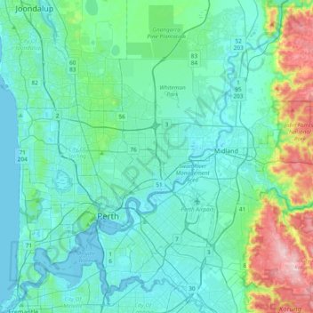
Nombre: Mapa topográfico Swan River, altitud, relieve.
Lugar: Swan River, Western Australia, Australia (-32.05494 115.73003 -31.73574 116.07277)
Altitud media: 57 m
Altitud mínima: -2 m
Altitud máxima: 353 m
Haz una donación
Otros mapas topográficos
Haga clic en un mapa para ver su topografía, su altitud y su relieve.
Perth
Australia > Western Australia > City of Perth
Perth, the capital of Western Australia, is situated on the Swan Coastal Plain, a flat expanse of sandy soil nestled between the Indian Ocean to the west and the Darling Scarp to the east. The Darling Scarp, also known as the Darling Range, is a low escarpment that extends north–south, marking a distinct…
Altitud media: 26 m
Haz una donación
Haz una donación
Haz una donación
Haz una donación
Haz una donación
Haz una donación
Haz una donación
Haz una donación
Haz una donación
Haz una donación
Perth
Australia > Western Australia > City of Perth
Perth, the capital of Western Australia, is situated on the Swan Coastal Plain, a flat expanse of sandy soil nestled between the Indian Ocean to the west and the Darling Scarp to the east. The Darling Scarp, also known as the Darling Range, is a low escarpment that extends north–south, marking a distinct…
Altitud media: 26 m
Haz una donación
Haz una donación
Haz una donación
Haz una donación
Haz una donación
Mount Meharry
The summit of Mount Meharry can be reached from the Great Northern Highway via an unsealed road 16 kilometres (9.9 mi) in length and a vehicular track 21 kilometres (13 mi) in length. Permission should be sought from the managers of the land over which the road and track pass. These are Juna Downs Station and…
Altitud media: 1.030 m
Haz una donación
Haz una donación
Haz una donación
Haz una donación
Haz una donación
Haz una donación
Nullarbor Plain
Australia > Western Australia > Forrest
One theory is that the whole area was uplifted by crustal movements in the Miocene, and since then, erosion by wind and rain has reduced its thickness. The plain has most likely never had any major defining topographic features, resulting in the extremely flat terrain across the plain today.
Altitud media: 131 m
Haz una donación
Haz una donación
Haz una donación
Gibson Desert
The Gibson Desert is located between the saline Kumpupintil Lake and Lake Macdonald along the Tropic of Capricorn, south of the Great Sandy Desert, east of the Little Sandy Desert, and north of the Great Victoria Desert. The altitude rises to just above 500 metres (1,600 ft) in places. As noted by early…
Altitud media: 464 m
Haz una donación