
Haz una donación
Mapa topográfico Albany
Haga clic en el mapa para ver la altitud.
Haz una donación
Acerca de este mapa
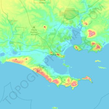
Nombre: Mapa topográfico Albany, altitud, relieve.
Lugar: Albany, City of Albany, Western Australia, 6330, Australia (-35.18478 117.72361 -34.86478 118.04361)
Altitud media: 30 m
Altitud mínima: -3 m
Altitud máxima: 226 m
Haz una donación
Otros mapas topográficos
Haga clic en un mapa para ver su topografía, su altitud y su relieve.
Haz una donación
Haz una donación
Haz una donación
Haz una donación
Haz una donación
Henley Brook
Henley Brook is situated on the flood plains of the Swan River, with regularly occurring seasonal floods. Two ephemeral streams from the river - Henley Brook and St. Leonard's Creek - traverse the suburb. Henley Brook is in the north-east near Brockman Street, while St Leonards Creek traverses the centre of…
Altitud media: 28 m
Haz una donación
Haz una donación
Haz una donación
Haz una donación
Purnululu National Park
The Bungle Bungle Range, lying fully within the park, has elevations as high as 578 metres (1,896 ft) above sea level. It is famous for the sandstone domes, unusual and visually striking with their striping in alternating orange and grey bands. The banding of the domes is due to differences in clay content and…
Altitud media: 277 m
Haz una donación
Haz una donación
Haz una donación
Haz una donación
Haz una donación
Mount Melville
Australia > Western Australia > Albany
The mount has an elevation of 152 metres (499 ft).
Altitud media: 36 m
Haz una donación
Haz una donación
Haz una donación
Haz una donación
Haz una donación
Haz una donación
Kalbarri
Kalbarri is a coastal town in the Mid West region located 592 km (368 mi) north of Perth, Western Australia. The town is located at the mouth of the Murchison River, which has an elevation of 6 metres (20 ft). It is connected by public transport to Perth via Transwa coach services N1 and N2.
Altitud media: 57 m
Haz una donación
Haz una donación
Haz una donación
Haz una donación
Haz una donación