
Mapa topográfico Albany
Mapa interactivo
Haga clic en el mapa para ver la altitud.
Acerca de este mapa
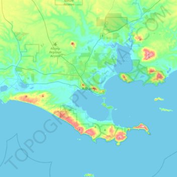
Nombre: Mapa topográfico Albany, altitud, relieve.
Lugar: Albany, City Of Albany, Western Australia, 6330, Australia (-35.18478 117.72361 -34.86478 118.04361)
Altitud media: 30 m
Altitud mínima: -3 m
Altitud máxima: 226 m
Otros mapas topográficos
Haga clic en un mapa para ver su topografía, su altitud y su relieve.
Cape Range National Park
The Cape is the only elevated plateau composed of limestone on the North West Coast. The range has plateaus to an elevation of 314 metres (1,030 ft) and forms the backbone of the peninsula which extends as far as North West Cape.
Altitud media: 55 m